According to the National Oceanic and Atmospheric Administration’s (NOAA) National Hurricane Center (NHC), as of 11:00 a.m. Eastern Daylight Time (EDT), a Hurricane Warning is in effect for communities across Florida’s west coast, from Bonita Beach to Suwannee River, and east coast, from the St. Lucie/Martin County Line to Ponte Vedra Beach. Hurricane Milton is currently a major Category (Cat) 4 storm and is projected to make landfall along the west-central coast of Florida on the evening of Wednesday, October 9, or in the early morning of Thursday, October 10. NHC officials state that Milton is expected to remain an extremely dangerous hurricane when it reaches the coast of Florida and makes its way across the state.
At 11:00 a.m. EDT, the NHC reported that Hurricane Milton was in the Gulf of Mexico, about 160 miles West-Southwest of Fort Myers, Florida, and 190 miles Southwest of Tampa, Florida. The storm’s maximum sustained winds are near 145 miles per hour (mph) with hurricane force winds extending outward up to 35 miles and tropical storm force winds extending outward up to 175 miles from the center.
In anticipation of Milton’s landfall, Storm Surge Warnings have been issued for communities along the western coast of Florida as well as from Sebastian Inlet, Florida, to Altamaha Sound, Georgia. The NHC warns of extremely life-threatening storm surge, with the highest inundations of up to 10 feet or more. Additionally, mandatory evacuations are in place for at least 15 counties along the west and upper east coast of the state, spanning from Levy to Collier County in west Florida, and St. Johns to Volusia County in east Florida. Voluntary evacuations are also in place for 13 counties with local officials recommending that people living in mobile homes, “substandard housing,” or flood-prone areas evacuate to a shelter or other safe locations. The Florida Division of Emergency Management (FDEM) has announced there are 155 shelters open throughout the state, including seven state-operated facilities.
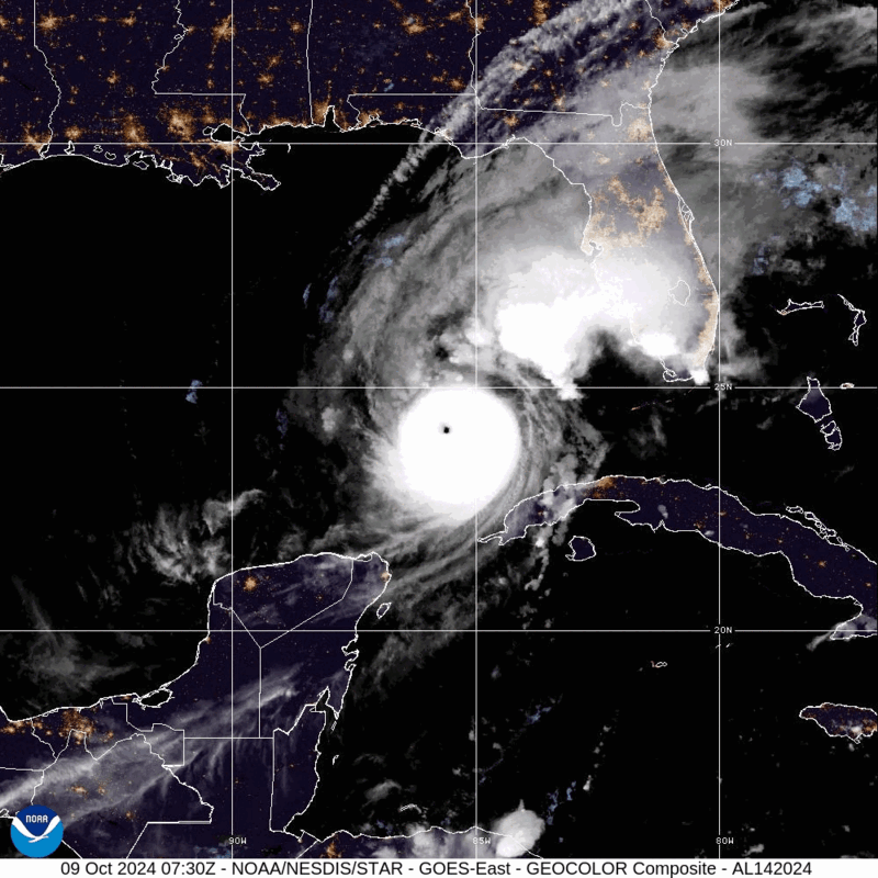
Hurricane Milton – GeoColor: NOAA
Prior to landfall, as of Wednesday, October 9, south Florida is experiencing bands of heavy rain and strong winds gusting up to 59 miles per hour (mph) in Key West, Florida, and at least one tornado has been reported near Big Cypress Seminole Reservation, 22 miles southeast of Montura, Florida.
Intense rainfall, hurricane-force winds, and storm surge are among the most severe hazards faced by communities along Milton’s path. The NHC forecasts between six and 12 inches of rainfall across central to northern portions of the Florida Peninsula through Thursday, October 10, with localized rainfall totals up to 18 inches. The rain of this volume has the potential to bring catastrophic flooding to portions of Florida. Additionally, officials are anticipating extreme hurricane-force winds once Milton makes landfall that will sustain as the storm crosses the state, causing structural damage and widespread, multi-day power outages.
Other hazards include inland flooding due to the combination of dangerous storm surge and tides, which are expected to cause potential life-threatening inundation from rising water, with the deepest water occurring near and immediately south of Milton’s landfall. The latest forecast from the NHC warns that storm surge could range from eight to 15 feet above ground level along Florida’s west-central coast, including a forecasted surge level of 10 to 15 feet from Anna Maria Island to Boca Grande, and eight to 12 feet in the Tampa Bay area. In addition to the dangerous rainfall and storm surge conditions, the risk of severe tornadoes will exist through Wednesday, October 9. The NHC reports that tornadic supercells from Milton have already begun to sweep across the Southern Florida Peninsula.
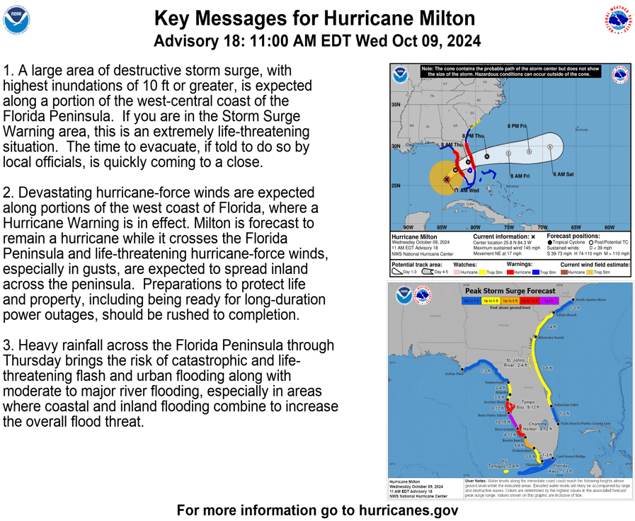
Key Messages for Hurricane Milton: NWS
In advance of Hurricane Milton’s arrival, President Biden approved an Emergency Declaration for Florida on Monday, October 7, as well as an Emergency Declaration for the Seminole Native American Tribe on Tuesday, October 8. Additionally, on Sunday, October 6, Florida Governor Ron DeSantis amended Executive Order 24-214, increasing the number of counties with a declared state of emergency from 35 to 51. Counties throughout the middle of Florida, such as Hillsborough, where Tampa is located, and Orange, where Orlando is located, are all located in the projected path of Hurricane Milton. Counties further south, such as Miami-Dade and Palm Beach, are also included in the state of emergency declaration.
More than 5.5 million people have been urged to evacuate Florida’s west coast, making it one of the largest evacuations in Florida history after Hurricane Irma in 2017. Beginning on Monday, October 7, evacuations resulted in heavy traffic and long delays, especially on Interstate 75 (I-75). By the evening of Tuesday, October 8, approximately 17.4 percent of Florida’s gas stations were reporting fuel shortages. To alleviate this, Governor DeSantis urged residents to evacuate only as far away as they needed and stated that the State is working to bring in emergency supplies of gasoline. FDEM is operating free evacuation shuttles in counties with an evacuation order in place and has partnered with Uber to provide free rides to evacuees seeking transportation to hurricane shelters.
Additional efforts to prepare for Hurricane Milton’s landfall are ongoing as Tampa, Florida, and surrounding areas are still recovering from Hurricane Helene’s impacts. Debris removal has been one of the largest concerns. The city of Tampa has collected more than 26,000 cubic tons of debris, but has not had time to remove all the debris left over in the two weeks since Hurricane Helene’s landfall. The City has urged residents to secure or move large debris, like appliances, prior to Hurricane Milton’s arrival. Residents with electric vehicles are also encouraged to move their vehicles to free city-owned public garages to avoid potential fires. Additional state preparedness efforts, coordinated by FDEM, include the distribution of water, Meals Ready to Eat (MREs), sandbags, and tarps. FDEM has post-landfall responders staged in Jacksonville, Perry, Ft. Lauderdale, and Miami, Florida. In addition, the Florida National Guard (FLNG) has activated 5,000 service members along with 11 search and rescue aircraft, and the Florida State Guard has activated and mobilized soldiers throughout the state.
Florida: #Milton could bring tornado threats to some areas. Do you know the difference between a tornado watch and a warning?
️ WATCH = Stay alert & be ready to shelter.
️ WARNING = Take shelter immediately in a safe place.More: https://t.co/uS3UijRCxl pic.twitter.com/jE31RxuMMj
— Readygov (@Readygov) October 8, 2024
X: Ready.gov
The NHC warns that Hurricane Milton poses an “extremely life-threatening” storm surge risk to many coastal communities. To help individuals prepare for these conditions, NOAA provides information on storm surge warnings and storm surge watches. Additionally, FEMA provides guidance to individuals preparing for, experiencing, or affected by hurricanes. Flash floods can develop with little to no warning, quickly changing the surrounding area. FEMA suggests individuals seek higher ground, avoid walking or driving in flood waters, and heed the warnings of local authorities.
Additionally, a tornado can occur anytime and anywhere, necessitating that all individuals be prepared for the potential of tornado impacting their community. One essential preparedness measure is to sign up for emergency alerts and warnings in order to stay informed on local weather forecasts and follow instructions from emergency officials. During severe weather, it is important to know the differences between and pay attention to the NWS’s three key alerts:
- Tornado Watch – indicates that conditions are favorable for producing a tornado in or near the watch area (which may cover several counties or states) and alerts you to review your emergency plans and be ready to act in the event of an emergency.
- Tornado Warning – issued by your local forecast office when a tornado has been sighted or determined by radar (typically within a city or small county) and is a signal to take shelter until the warning has expired.
- Tornado Emergency – the NWS’s highest alert issued when there is confirmation of a tornado touch down in the area, necessitating that everyone in the emergency immediately seek shelter in the safest location possible.
Over the coming days and weeks, Hagerty’s Blog Team will continue to provide guidance on making effective preparations for long-term recovery, as well as continuing our situational updates.
Stay Updated and Learn More
Remember, Ready.gov provides information on how to prepare for a storm and keep you and your family safe.