MONDAY, JUNE 8, 2020 AS OF 11:30 AM EDT
Cristobal made landfall as a tropical storm between the mouth of the Mississippi River and Grand Isle in Louisiana on the evening of Sunday, June 7, with the National Oceanic and Atmospheric Administration’s (NOAA) National Hurricane Center (NHC) issuing a storm warning for the mouth of the Mississippi River to Ocean Springs Mississippi. The NHC reported the storm’s eye is approximately 40 miles north of Baton Rouge, Louisiana, and has continued to weaken, with maximum sustained winds of 35 miles per hour (mph). The storm could result in flash flooding across the Mississippi River Valley in Arkansas, Mississippi, and Louisiana. Cristobal was additionally responsible for a tornado that touched down near Orlando, Florida on the evening of Saturday, June 6. There were no injuries or fatalities, but NBC News stated there were reports of power outages.
4am CDT Key Messages on Tropical Depression #Cristobal. A Storm Surge Warning remains in effect from the mouth of the Mississippi River to Ocean Springs, Mississippi. Heavy rain is expected to spread northward during the next few days. https://t.co/tW4KeFW0gB pic.twitter.com/nNDaC9hBsB
— National Hurricane Center (@NHC_Atlantic) June 8, 2020
Key Messages for Tropical Storm Cristobal: NWS Twitter
On Sunday, June 7 the NHC’s Tropical Analysis and Forecast Branch in Miami, Florida tweeted there were peak seas of 25 feet south of Louisiana, but that the winds and seas throughout the Gulf of Mexico were expected to diminish on Monday, June 8. According to The Weather Channel, the remnants of the storm are anticipated to result in heavy rainfall for certain parts of Missouri to western Illinois, before moving into eastern Iowa, southeastern Minnesota, Wisconsin, and northern Michigan, with a risk of localized flash flooding and strong winds.
Louisiana Governor John Bel Edwards issued a state of emergency on Friday, asking President Donald Trump to announce a pre-landfall emergency for Louisiana due to the threat of Cristobal. On Sunday, President Trump declared an emergency for the State of Louisiana and ordered Federal assistance to help with State, tribal, and local response efforts for Cristobal, authorizing the Department of Homeland Security (DHS) and the Federal Emergency Management Agency (FEMA) to coordinate all disaster relief efforts. FEMA Administrator Pete Gaynor identified Federal Coordinating Officer (FCO) John E. Long as the officer for Federal recovery operations in the impacted areas.
Cristobal now looks like a typical tropical storm w/a more symmetric shape evident in satellite imagery. It has a large eye-like feature consisting of swirly low clouds w/convection firing up on the west side. The storm’s center is just offshore so landfall hasn’t occurred yet. pic.twitter.com/QF5gOSUG7W
— NWS Tallahassee (@NWSTallahassee) June 7, 2020
Cristobal Satellite Imagery : NWS Tallahassee
The NWS offers advice and guidance for those about to experience, currently being impacted by, or previously affected by tropical storms and hurricanes. Individuals at risk are encouraged to secure their home, remain up-to-date with the local NWS office and local government/emergency management office, and follow guidance issued by local officials. Additionally, FEMA encourages individuals to prepare before a tropical storm or hurricane. The Hagerty Blog Team will continue providing information and updates.
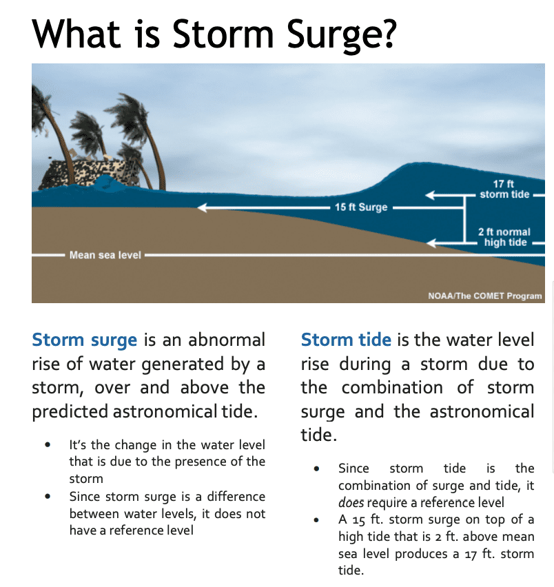
What is Storm Surge: NHC
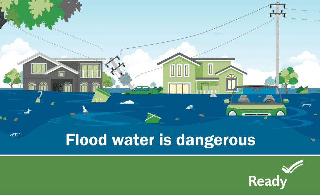
FEMA Guidance Flood Water: FEMA
RELATED STORIES
- Remember, Ready.gov provides information on how to prepare for a storm and how to keep you and your family safe
- COVID-19 Pandemic Operational Guidance for the 2020 Hurricane Season
Keep track of Hagerty’s coverage here:
HURRICANE SEASON 2020