THURSDAY, AUGUST 20, 2020 AS OF 8:00 AM PST
The National Oceanic and Atmospheric Administration (NOAA) National Weather Service (NWS) issued a red flag warning for the critical active and contained fires that have spread throughout Northern California; the fires have resulted in thousands of evacuations and structures burned.
There are currently 32 active fires burning across California, of which only three fires are more than 50 percent contained. According to the California Government’s Cal Fire webpage, the largest area affected is the LNU Lightning Complex, which is impacting 124,000 acres across Napa, Sonoma, Lake, Yolo, and Solano Counties. Also impacting Northern California communities, the SCU Lightning Complex fire is the largest, taking up multiple locations across Santa Clara County, Alameda County, Contra Costa County, San Joaquin County, and Stanislaus County. The fire has been active for a day and more than 102,000 acres have burned. It is presently only 5 percent contained. The Apple fire in Riverside County, California, is one of the earliest active fires of the season, igniting on July 31, with Cal Fire reporting that it’s 95 percent contained after burning 33,424 acres.
Cal Fire has noted 204,481 acres and 181 structures have been burned in total across the state. The intensity and speed of the flames have made it difficult for the thousands of firefighting personnel working to contain the different blazes, and NPR reported that the first casualty was a helicopter pilot on a water dropping mission on the Hills Fire in western Fresno County, California.
To date, the Federal Emergency Management Agency (FEMA) has approved four Fire Management Assistance Grants (FMAGs) for the LNU Lightning Fire Complex, the Jones Fire, the River Fire, and the Apple Fire. These grants are designed to mitigate the immediate threats to life, property, and safety by providing expeditious federal assistance to the State of California. This grant funding can support expenses for field camps; equipment use, repair and replacement; tools, materials, and supplies; and firefighting mobilization and demobilization activities.
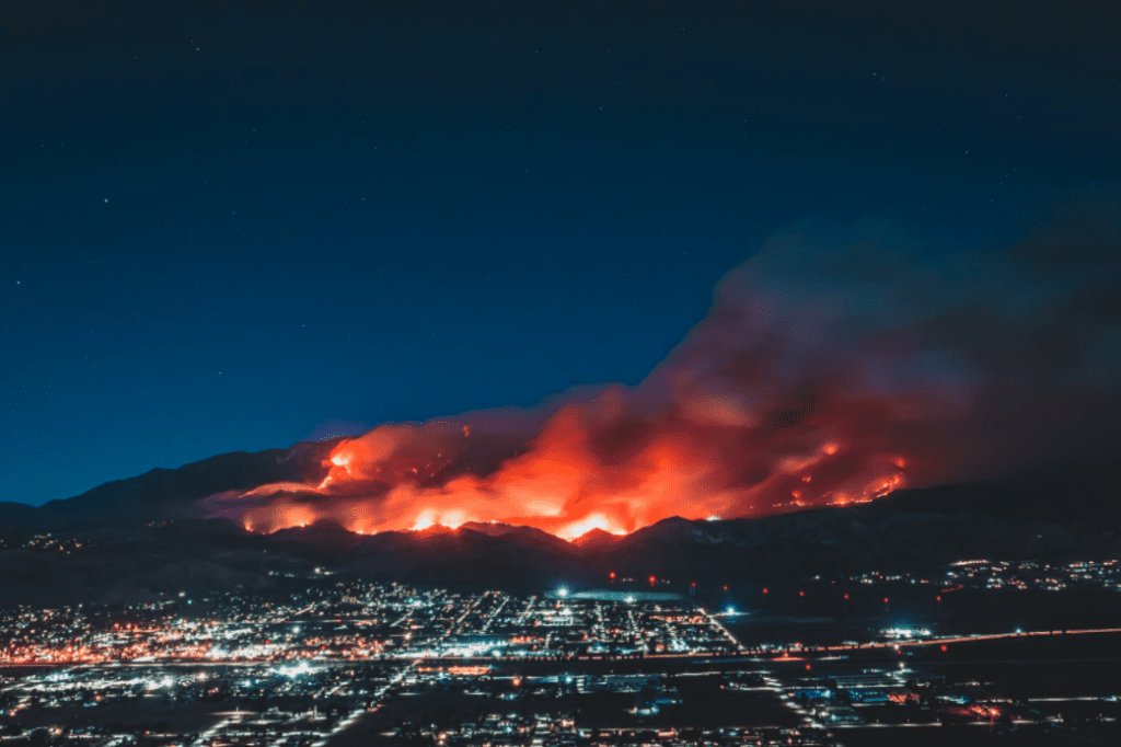
UnSplash: Levan Badzgaradze
The New York Times noted there have been thousands more fires in 2020 than in the previous year; there have been 6,754 fires in California this year, compared with approximately 4,000 in 2019. On Wednesday August 19, California Governor Gavin Newsom issued a state of emergency to provide more resources to fight the hundreds of wildfires brought on by heat and sustained high winds. According to the emergency proclamation, the fires in California have put pressure on the state’s mutual aid system, which has made it challenging for different jurisdictions to receive the resources necessary to combat the different blazes. Newsom mobilized the California National Guard to help with relief, and the governors of Texas and Arizona have provided resources to support response in California, according to The New York Times.
Have you noticed the colorful sunsets lately? Unfortunately, the reason is smoke from wildfires across CO and CA. Here is a models depiction of where the smoke will be in the next 24 hours. Most of this smoke will remain elevated and not affect air quality today. #lubwx #txwx pic.twitter.com/KJ2M1HU01H
— NWS Lubbock (@NWSLubbock) August 19, 2020
NWS Lubbock:Twitter
Evacuations have been taking place across the state. The Travis Air Force Base in Solano County, which employs over 14,000 personnel, issued mandatory evacuation for all “non-mission essential personnel.” Additionally, CNN reports emergency evacuation orders have been issued for Vacaville, California, as well as counties across Northern California that include Sonoma, Lake, and Napa County.
If the air quality is affected in your area due to the wildfires, use these tips and resources:
✅ Follow @AIRNow or visit https://t.co/IbyuPHgM88 for real-time air quality updates.
✅ Follow @CDCemergency for tips if you have medical needs: https://t.co/cFnPZrpecA pic.twitter.com/lJREV96zXN— Readygov (@Readygov) August 19, 2020
Tweet: Ready.gov
Ready.gov encourages individuals to prepare and plan for wildfires. These events can develop quickly. It’s never too soon to prepare for a wildfire event. Individuals should follow the guidance of local authorities and remain safe as most of the fires are largely uncontained. The Hagerty Blog Team will continue providing information and updates on current events and disasters impacting the nation, visit Disaster Discourse for the latest information.
EVACUATIONS AND EMERGENCY DECLARATIONS
The Governor of California, Gavin Newsom, has declared a State of Emergency amid the scale and magnitude of fires that are burning throughout California.
Here’s the breakdown of public advisories from NOAA’s NWS in decreasing order of severity:
RED FLAG WARNINGS:
- Lake County Portion of Lake-Napa-Sonoma Unit
- Burney Basin and Northeast Plateau in Shasta County Including Northwest Lassen NF north of Lassen NP
- Central Sacramento Valley including Glenn, Colusa, Yuba, Northern Sutter, Butte County Below 1000 Ft
- Eastern Delta
- Eastern Mendocino NF
- Eastern Portion of Shasta, Trinity NF
- Northern Motherlode From 1000 to 3000 Ft. From Yuba To Amador Counties
- Northern Sacramento Valley to Southern Tehama County Line Below 1000 Ft
- Northern San Joaquin Valley in San Joaquin and Stanislaus Counties Below 1000 ft – Excludes the Delta
- Northern Sierra Foothills from 1000 to 3000 Ft. Includes Nevada-Yuba-Placer RU and Anador-Eldorado RU
- Northern Sierra Including Lassen NP and Plumas and Lassen NF, S West of the Sierra Crest – West of Evans Peak, Grizzly Peak, Beckworth Peak
- Southeast Edge Shasta, Trinity NF and Western Portions of Tehama, Glenn RU
- Southern Sacramento Valley In Yolo, Sacramento, Far Western Placer, Southern Sutter and Solano County Below 1000 Ft – Excludes the Delta; Tahoe – Eldorado National Forest
Air Quality Alert:
- Fresno
- Kern
- Kings
- Madera
- Merced
- San Joaquin
- Stanislaus
- Tulare
- Ventura County Interior Valleys
- San Luis Obispo County Central Coast
- San Luis Obispo County Interior Valleys
- San Luis Obispo County Mountains
RELATED STORIES
- Remember, Ready.gov provides information on how to prepare for Wildfire and how to keep you and your family safe.
- The Los Angeles Times regularly updated tracking of California Wildfires:California Wildfires Map.
- The National Fire Protection Association provides wildfire preparedness tips: link
- Marin County provides a wildfire evacuation checklist: link
- FEMA provides an information video about how to be prepared for Wildfires: link