According to the National Oceanic and Atmospheric Association’s (NOAA) National Hurricane Center (NHC), Hurricane Laura made landfall as a Category 4 hurricane near Cameron, Louisiana on Thursday, August 27 (today) at 2:00 AM EDT. At the time of landfall, Laura had developed a clear, circular eye and strong eyewall. With intense, tightly coiled bands, Hurricane Laura brought hurricane-force winds and devastating storm surge and flooding to nearby areas. Since making landfall, Laura has rapidly downgraded and is currently a Category 2 storm with wind speeds up to 110 mph, moving north at 15 miles per hour (mph) across eastern Texas, western Louisiana and into southern Arkansas.
The NHC warns communities near and around the path of Laura could experience unsurvivable storm surge, as far as 40 miles inland from the coast. According to the NOAA Storm Surge Map, coastal communities already received approximately three feet of storm surge, with certain areas potentially experiencing more than nine feet of storm surge in total. Storm surge warnings have been issued for High Island, Texas to the Mouth of the Mississippi River. As Laura continues to move inland, storm surge and tornadoes are possible. Additionally, flood waters are expected to remain stagnant for many days in hurricane-impacted areas before receding. Currently over 440,000 customers are without power throughout Louisiana and Texas.
For communities threatened by storm surge from Hurricane Laura and future storms, Hagerty’s Executive Chairman Brock Long shares lessons learned and best practices, including adhering to the guidance of local authorities.
Ahead of the storm, Federal Emergency declarations were approved for Louisiana, Mississippi, and Texas. These declarations help the Federal Emergency Management Agency (FEMA) rapidly and efficiently respond to states and individuals where aid is needed post-disaster. They authorize FEMA to provide assistance, including reimbursement for mass care, evacuation, and shelter support.

NOAA Guidance Flood Safety: Source
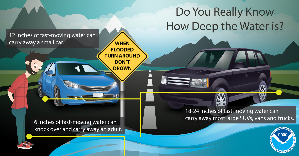
Additionally, FEMA provides guidance to individuals preparing for, experiencing, or affected by hurricanes. Hurricane Laura brings potential for life-threatening storm surge to many coastal communities. Individuals should heed the warnings of local authorities and prepare for hurricane and severe weather conditions.
Over the coming days and weeks, Hagerty will continue to provide guidance regarding effective preparedness strategies for long-term recovery, as well as continuing our situational updates.
PUBLIC ADVISORIES
Here’s the breakdown of public advisories from NOAA’s NHC:
STORM SURGE WARNING:
- High Island Texas to the Mouth of the Mississippi River
HURRICANE WARNING:
- High Island Texas to Intracoastal City Louisiana
TROPICAL STORM WARNING:
- East of Intracoastal City Louisiana to the Mouth of the Mississippi River
RELATED STORIES
- Remember, during a storm, it is important to follow the directions of your state and local officials. Ready.gov provides information on how to prepare for a storm and how to keep you and your family safe throughout.
- Understanding the meaning of hurricane maps – a NY Times Opinion Piece: Those Hurricane Maps Don’t Mean What You Think They Mean
Keep track of Hagerty’s coverage here:
HURRICANE SEASON 2020