MONDAY, SEPTEMBER 26, 2022 AS OF 11:00 AM EDT
According to the National Oceanic and Atmospheric Administration (NOAA) National Hurricane Center (NHC), Hurricane Ian, a Category (Cat) 1 hurricane, is moving northwest towards the Cayman Islands at approximately 14 miles per hour (mph), with maximum sustained winds of 75 mph, as of 5:00 a.m. Eastern Daylight Time (EDT). Ian’s path is forecasted to potentially shift north-northwest sometime on Monday, with Hurricane-force winds reaching outward up to 15 miles from the center and tropical storm winds extending outwards up to 90 miles.
Hurricane Ian is projected to bring possible swells to Jamaica and the Cayman Islands today, and expected to affect the Florida’s Keys and the west coast of Florida Tuesday and Wednesday. Ian is also projected to bring heavy rains to the Cayman Islands, Western Cuba, Florida Keys, and parts of Florida. The NHC cautions that flash and urban flooding is possible in some areas of Florida.
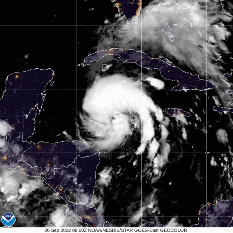
Hurricane Ian – GeoColor: NOAA
The State of Florida has been preparing for the arrival of Hurricane Ian since last week; on Friday, September 23, Florida Governor Ron DeSantis issued an Executive Order to declare a state of emergency across 24 counties in the Florida peninsula. President Joe Biden and the Federal Emergency Management Agency (FEMA) approved Florida’s Emergency Declaration, allowing for Category B Public Assistance providing direct federal assistance and emergency protective measures support to the state.. Moreover, FEMA is supporting Florida and surrounding states by moving supplies and personnel to strategic distribution centers to ensure that they are prepared to activate as needed throughout the most severe storm days. Among those resources are over 4,000 reservists and an additional 7,500 Surge Capacity Force members that FEMA has activated to support ongoing needs related to Hurricane Ian.
On Sunday September 25, the Florida Division of Emergency Management (FDEM) and Governor DeSantis held a press conference calling for residents to make preparations and stock up on supplies ahead of the storm, including fuel for vehicles, non-perishable food items, reserves of fresh water, batteries, and prescription drugs and medicine. Governor DeSantis warned that residents should “anticipate power outages and fuel disruptions with a hurricane of this magnitude,” and should look to news sources and FDEM to check for evacuation warnings. He also expanded the September 23 Executive Order to include all 67 counties in Florida, given the uncertainty of the path of the storm, to ensure that all counties can utilize federal resources. FDEM Director, Kevin Guthrie, highlighted that the State is preparing for the likelihood of dangerous storm surge by contacting emergency operations center (EOC) leaders in each of the 67 counties and state agencies to ensure a coordinated response to additional water to coastal areas. Director Guthrie called for residents to “know their zones,” and check with the FDEM evacuation zone map as directed to stay up-to-date.
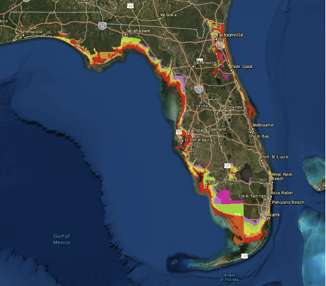
“Know Your Zone” Evacuation Tracker: FDEM
The Florida Department of Education (FLDOE), which oversees all public K-12 schools, the Florida College System, and State Universities, announced closures on Sunday ahead of Hurricane Ian’s arrival. Among those listed are the University of South Florida, which has canceled classes through Thursday, September 29, and public schools in Hillsborough, Lake, Pasco, and Pinellas Counties. Floridians are encouraged to continue checking for closures and evacuation orders using Florida 511 and Florida Storms, a Florida Public Radio Emergency Network in addition to local official’s offices and FDEM.
POST-TROPICAL STORM FIONA
After moving through the Caribbean as a Cat 1 hurricane, now post-tropical storm (cyclone) Fiona continued its path through the Atlantic towards Canada. After strengthening to a Cat 4 hurricane, it was downgraded to a post-tropical storm before making landfall on the Canadian coast early Saturday morning. Despite being downgraded to a post-tropical storm, hurricane strength winds, rain, and storm surges still impacted parts of Nova Scotia, Prince Edward Island, Newfoundland, and Quebec. A state of emergency was declared for the town of Port aux Basques in Newfoundland, and part of the community was under an emergency evacuation order. Evacuations were made increasingly difficult as flooding made some roads impassable, and initial estimates of eight to twelve houses were completely washed away to sea. Nearly all of Prince Edward Island and parts of Nova Scotia lost power. The ongoing inclement weather made restoring power slow; however, power is gradually being restored leaving about 200,000 customers without power throughout the provinces of New Brunswick and Nova Scotia as of Monday morning. Canadian Armed Forces troops have been sent to Nova Scotia, Prince Edward Island and Newfoundland and Labrador to assist with response and recovery efforts. According to the Canadian Hurricane Center, the recorded pressure of post-tropical storm Fiona when it made landfall in Canada was 931.6 millibar (mb), which is generally a value that can be seen in a smaller, but intense Cat 4 hurricane. Such a reading would make it the lowest-pressured land falling storm on record for Canada.
Additionally, the impacts of Fiona are still being felt in Puerto Rico. According to Poweroutage.us nearly 750,000 residences and businesses are still experiencing power outages across the island.
As Tropical Storm #Ian develops, we encourage Floridians to:
Have a hurricane plan in place.
Follow directions from local officials. Evacuate if asked to.
Download the FEMA App: https://t.co/5k6zIiBVhZ pic.twitter.com/IBT198OjwO— FEMA (@fema) September 25, 2022
Twitter: FEMA
FEMA encourages individuals to prepare before a tropical storm or hurricane. After determining the risks of severe weather in your community, it is critical to:
- Collaborate with family members and household partners to ensure everyone knows how to reliably receive emergency alerts;
- Know where to seek shelter inside and outside of the home (dependent on the guidance);
- Know how to find the safest evacuation routes;
- Know how everyone will maintain communication during the crisis; and
- Create an emergency kit that is fully stocked for at least three days.
Individuals at risk are encouraged to secure their home, remain up-to-date with information from their local NWS office and local government/ emergency management office, and follow guidance issued by local officials. Emergency plans should be personalized based upon the unique composition of families and their households, considering the needs of young children, older adults, and pets, dietary and medical requirements, and individuals living with disabilities. FEMA suggests several precautionary steps people can take to protect their homes and personal properties from damage by high winds and floods, including reviewing flood insurance coverage.
STAY UPDATED AND LEARN MORE HERE:
- Remember, Ready.gov provides information on how to prepare for a storm and how to keep you and your family safe.
- Understanding the meaning of hurricane maps – a NY Times Opinion Piece: Those Hurricane Maps Don’t Mean What You Think They Mean