According to the National Oceanic and Atmospheric Administration’s (NOAA) National Hurricane Center (NHC), Hurricane Francine made landfall near Morgan City, Louisiana, around 5:00 pm Central Time (CT) on Wednesday, September 11. Initially a Category (Cat) 2 hurricane, it weakened to a tropical storm. As of 5:00 a.m. Eastern Daylight Time (EDT), the NHC is also tracking Tropical Depression Seven in the Atlantic as it moves West-Northwest.
Francine currently has maximum sustained winds of up to 45 miles per hour (mph), extending outward up to 150 miles as it tracks northeast at 12 mph. In the United States (US), hurricanes are categorized according to the Saffir-Simpson Scale based on their wind speeds, with a Cat 1 reflecting 74 to 95 mph winds and a Cat 5 indicating hurricanes with wind speeds of 157 mph or higher. The NHC estimates that with Cat 2 strength at landfall, dangerous winds will cause extensive damage, including major roof and siding damage to well-built homes, shallowly rooted trees to be snapped or uprooted, causing road blockage, and widespread power outages that could last several days to weeks.
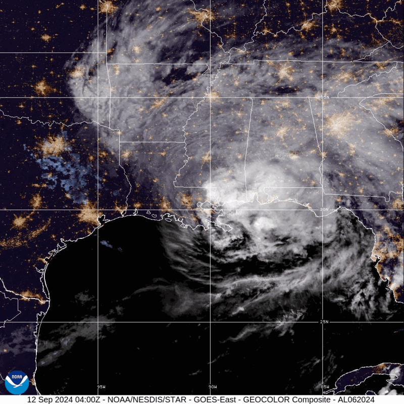
Tropical Storm Francine – GeoColor
As of 5:00 a.m. EDT, more than 391,000 Louisiana customers and around 41,000 Mississippi customers were without power. In addition to power outages, several other hazards currently exist, including storm surge, heavy rainfall, flooding, and tornadoes. The NHC warns of the potential for life-threatening storm surge along portions of the eastern Louisiana and Mississippi coastlines, where Storm Surge Warnings are currently in effect. The dangerous storm surge, combined with high tides, could flood normally dry areas with up to six feet of water moving inland. Additionally, heavy rainfall of three to six inches is expected across portions of Alabama, Arkansas, the Florida Panhandle, Georgia, Mississippi, and Tennessee, with certain areas potentially receiving up to 10 inches. This could lead to significant flash and urban flooding.
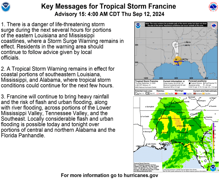
Key Messages for Tropical Storm Francine: NHC
Additionally, there is a possibility of scattered tornadoes from the Florida Panhandle to Central Alabama, as rain bands stretch across the area — tropical systems often produce tornadoes embedded in rain bands. Ahead of Francine’s landfall, on September 10, President Biden approved Louisiana’s emergency declaration, ordering Federal assistance to supplement State, tribal, and local response efforts.
#Francine will continue to bring heavy rains to Louisiana, Mississippi, and Alabama.
Remember that flash flooding is extremely dangerous.
Do not drive, walk, or swim through flooded waters.
Learn more: https://t.co/FB6rm0Zhg5 pic.twitter.com/03ZPVFRW6v
— Readygov (@Readygov) September 11, 2024
X: Ready.gov
Tropical Storm Francine brings potential life-threatening flooding and tornadoes to many communities. The Federal Emergency Management Agency (FEMA) provides guidance to individuals preparing for, experiencing, or affected by hurricanes. Additionally, FEMA encourages individuals to take the necessary precautions and prepare for flash flooding. Flash floods can develop with little to no warning, quickly changing the surrounding area. FEMA suggests individuals seek higher ground, avoid walking or driving in flood waters, and heed the warnings of local authorities.
Additionally, a tornado can occur anytime and anywhere, necessitating that all individuals be prepared for the potential of a tornado impacting their community. One essential preparedness measure is to sign up for emergency alerts and warnings in order to stay informed on local weather forecasts and follow instructions from emergency officials. During severe weather, it is important to know the differences between and pay attention to the NWS’s three key alerts:
- Tornado Watch – indicates that conditions are favorable for producing a tornado in or near the watch area (which may cover several counties or states) and alerts you to review your emergency plans and be ready to act in the event of an emergency.
- Tornado Warning – issued by your local forecast office when a tornado has been sighted or determined by radar (typically within a city or small county) and is a signal to take shelter until the warning has expired.
- Tornado Emergency – the NWS’s highest alert issued when there is confirmation of a tornado touch down in the area, necessitating that everyone in the emergency immediately seek shelter in the safest location possible.
Stay Updated and Learn More
Remember, Ready.gov provides information on how to prepare for a storm and keep you and your family safe.