According to the National Oceanic and Atmospheric Administration’s (NOAA) National Hurricane Center (NHC), Hurricane Helene made landfall in Florida’s Big Bend Region on September 26, as a Category (Cat) 4 hurricane before weakening to a Tropical Storm as it moved north then pivoted northwest over Georgia, the Carolinas, Tennessee, and Virginia. Due to the sheer size of Hurricane Helene, with a wind field radius of approximately 350 miles, impacts from Hurricane Helene, such as heavy rain and wind gusts of up to 68 miles per hour (mph), were felt as far north and west as Illinois.
As of Monday, September 30, Post-Tropical Cyclone Helene is moving toward the Mid-Atlantic, where forecasters predict heavy rain will impact Maryland, Virginia, and West Virginia. Officials caution that the storm has the potential to bring elevated flood threats to these states. Helene has resulted in catastrophic impacts, including at least 116 fatalities, in communities across Florida, Georgia, North Carolina, South Carolina, Tennessee, and Virginia. As of 1:30 p.m. EDT, more than 1.9 million customers were without power throughout Florida, Georgia, North Carolina, South Carolina, and Virginia.
Today’s view of the Atlantic from @NOAA‘s #GOESEast satellite captures Tropical Storm #Helene, Hurricane #Isaac, and the newly-formed Tropical Storm #Joyce.
Get the latest updates: https://t.co/ScLdyBac9D pic.twitter.com/xDeigVXlxj
— NOAA Satellites (@NOAASatellites) September 27, 2024
X: NOAA Satellites
Additionally, the NHC reports multiple systems in the Atlantic: Tropical Depression Joyce, Post-Tropical Cyclone Isaac, and Tropical Storm Kirk. As of Monday, September 30, there are no forecasted impacts to land from Isaac or Joyce. The NHC continues to monitor Tropical Storm Kirk as it moves west, especially as it is anticipated to become a hurricane later this week.
Florida
Helene is the strongest hurricane on record to make landfall in Florida’s Big Bend, and the third hurricane to affect the region in the last 13 months. The impacts in Florida from this system range from loss of life to major destruction of homes and structures. Officials report more than 12 fatalities with crews still actively conducting rescue missions. In Taylor County, where the storm made landfall, the Sheriff’s office reports 90 percent of Keaton Beach homes were destroyed. Severe storm surge played a major role in widespread property damage, as water levels topped 15 feet in some regions, according to Florida Governor Ron DeSantis. In Tampa, storm surge reached seven feet, constituting the highest hurricane surge for the region in more than 100 years. Additionally, 120,000 customers and 54 healthcare facilities remain without power. Amid these impacts, as of Monday, September 30, nine counties across the State remain under mandatory evacuations with more than 26 shelters housing 795 occupants, according to FEMA.
Take a look at rescue efforts from our Marine Officers at 2:00 this morning.
Be aware, high tide has begun. Please stay off the roads so our officers and @tampafirerescue can swiftly assist those in need. pic.twitter.com/6gdyiAU1ir
— Tampa Police Department (@TampaPD) September 27, 2024
X: Tampa Police Department (PD)
Georgia and South Carolina
Heavy rain and tropical storm conditions began affecting areas of Georgia before Hurricane Helene made landfall in Florida. Despite weakening as it moved across Florida, Hurricane Helene was still a Cat 2 hurricane bringing heavy rainfall and high winds as it rapidly moved into Georgia early Friday, September 27. Rainfall totals in Georgia set records in several areas, including Atlanta, the state’s capital. A meter at the Hartsfield-Jackson Atlanta International Airport measured more than 11 inches of rain in 48 hours, breaking the record of 9.59 inches that was set in 1886. Swiftwater rescue teams worked to rescue residents in Atlanta as the heavy rainfall caused creeks and other bodies of water to overflow, leading to rapid flooding. According to Governor Brian Kemp, there have been 25 fatalities in Georgia from Hurricane Helene, including one first responder and two fatalities from a tornado in Alamo, Georgia. Valdosta, Georgia, located in the southern part of the state just across the border with Florida, experienced some of the heaviest impacts. The strong, continuous winds from Helene brought down trees, damaged structures, and blocked roads as it moved from Valdosta northward through Georgia, passing between Atlanta and Augusta. As of the morning of September 30, approximately 563,236 customers are still without power, primarily in the east and southeastern parts of Georgia.
According to Poweroutage.us, in South Carolina, over 733,000 customers remain without power. Across portions of South Carolina, between five and eight inches of rain fell within a 48-hour period, according to the NWS, prompting forecasts for nine rivers to go into flood stage over the coming days. Additionally, between Thursday, September 26, and Friday, September 27, six tornadoes, one EF-1 and five EF-0, occurred in the state associated with strong winds from Helene. Given these compounding hazards, the South Carolina Department of Public Safety (SCDPS) reports that there have been at least 25 storm-related fatalities throughout the State.
North Carolina
As Helene continued its path through Georgia and into western North Carolina, the storm was downgraded to a tropical storm and continued to produce sustained wind speeds of gusts of 35 mph. Conditions from Helene spawned multiple tornadoes in North Carolina during the storm, including one EF3 that touched down at 1:30 p.m. on Friday, September 27, in Rocky Mount, North Carolina. Prior to Hurricane Helene’s landfall, the NHC warned of potentially catastrophic flooding to the southern Appalachian areas due in part to already saturated conditions from a separate system that moved through the area on Wednesday, September 25. Tropical Storm Helene poured vast amounts of rainfall onto the Carolinas, leading to intense flooding, especially in the mountainous regions of western North Carolina and eastern Tennessee. Busick, North Carolina, located in Mount Mitchell State Park northeast of Asheville, recorded a record-breaking 30.78 inches of rain in 48 hours. Flash flooding and landslides caused by the heavy rainfall have cut off many areas in western North Carolina. Approximately 400 roads were impacted in the immediate aftermath of the storm, including Interstate 40 and Interstate 26, heavily impacting rescue operations. As of Monday, September 30, I-40 remains impassable at multiple locations, and I-26 is closed at the Tennessee state line, leading to the air drop of supplies for isolated towns. According to the North Carolina Department of Transportation (NCDOT), all roads in Western North Carolina should be considered closed, and non-emergency travel is prohibited.
Currently, approximately 457,582 customers are still without power in western North Carolina. Officials in Buncombe County, which includes Asheville, stated that cell phone towers are slowly coming back online, but cell phone service is still limited, and there is still no running water. As authorities work to clear roads and restore cell phone service, there are still at least 600 people unaccounted for in Buncombe County. As of Monday morning, 35 fatalities have been reported in North Carolina.. Rescue operations continue as additional rescue teams travel to western North Carolina from other parts of North Carolina and other states.
Tennessee
In Tennessee, officials report 153 people unaccounted for across the State after homes, hospitals, and infrastructure were inundated by floodwater, prompting widespread loss of power. Additional impacts include severe damage to roadways and bridges throughout the State. At the Tennessee-North Carolina border, flooding of the Pigeon River Gorge prompted a mudslide on Friday, September 27, that washed away a portion of Interstate 40 (I-40) spanning across Cocke County, Tennessee, through much of Western North Carolina. In Cocke County, Tennessee, water levels in the Pigeon River rose to nearly 29 feet, far surpassing the previous record of 23.4 feet for the area. According to data from the Tennessee Department of Transportation (TDOT), almost 30,000 vehicles travel through that portion of I-40 in both directions each day. Additionally, on Friday, September 27, the Tennessee Valley Authority (TVA) issued a Condition Red alert for the Nolichucky Dam, indicating that dam failure was imminent at the time. Water levels flowed at a rate of 1.3 million gallons per second, and reached peak water elevation at 1,266 feet — more than nine feet over the previous record elevation and doubling the previous flow rate record of 613,000 gallons per second, both set in 1977. However, by Saturday, September 28, TVA reported the Nolichucky Dam was stable and secure.
Helene also caused major flood damage to critical water infrastructure, prompting Newport Utilities to declare a state of emergency for all water operations on Sunday, September 29. Two boil water advisories remain active in the State as of Monday, September 30.
TEMA personnel are embedded with our local partners in Northeast Tennessee as response operations continue. We are gathering information on damage from the ground and in the air as we work with state and county officials to coordinate resources, support, and any other assistance… pic.twitter.com/1XHdnAwzhw
— Tennessee Emergency Management Agency (TEMA) (@TennesseeEMA) September 30, 2024
X: Tennessee Emergency Management Agency (TEMA)
As of Monday, September 30, President Biden has approved Major Disaster Declarations for Florida, North Carolina, and South Carolina. These declarations include access to FEMA Individual Assistance programs for eligible survivors with uninsured losses from the storms. To check your eligibility and/or apply for this funding, visit disasterassistance.gov, call 1-800-621-3362, or access the FEMA App.
Previously, the Biden-Harris Administration approved pre-landfall emergency declarations for Alabama, Florida, Georgia, North Carolina, Tennessee, South Carolina, and Virginia. These declarations order Federal assistance to State, tribal, and local response efforts.
Over the weekend, the Federal Emergency Management Agency (FEMA) Administrator Deanne Criswell traveled to Florida and Georgia, working with local and state officials to survey damage. Today, Monday, September 30, Administrator Criswell traveled to North Carolina to do the same.
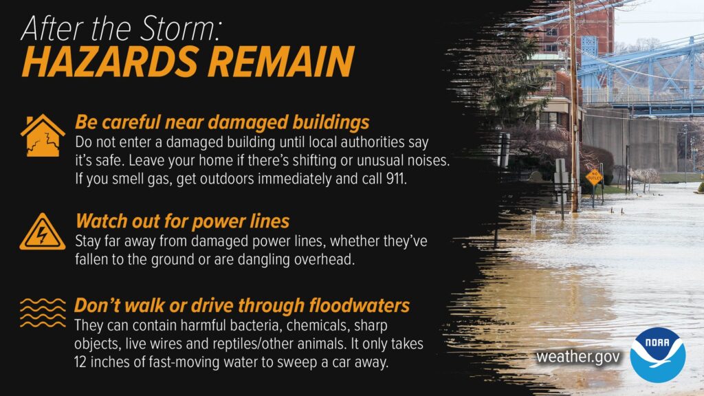
NOAA: After the Storm
As Post-Tropical Cyclone Helene continues to track north, communities in the storm’s path should begin preparations for potential tropical storm conditions, flooding, and heed the warnings of local authorities. FEMA provides guidance on the necessary precautions and preparations for flash flooding, as well as guidance to individuals preparing for, experiencing, or affected by hurricanes. Flash floods can develop with little to no warning, quickly changing the surrounding area. FEMA suggests individuals seek higher ground, avoid walking or driving in flood waters, and heed the warnings of local authorities.
Additionally, as power outages persist across numerous states, it is important to practice generator safety. According to the Federal Emergency Management Agency (FEMA), there are several safety precautions to keep in mind when using a generator, including: reading the manufacturer’s instructions and not using generators indoors, in partially enclosed spaces, or near open doors or windows. The NWS also recommends that generators be placed at least 20 feet away from doors, windows, and garages.
Stay Updated and Learn More
Remember, Ready.gov provides information on how to prepare for a storm and keep you and your family safe.