MONDAY, JULY 8, 2024, AS OF 8:30 AM EDT
According to the National Oceanic and Atmospheric Administration’s (NOAA) National Hurricane Center (NHC), as of 5:00 a.m. Eastern Daylight Time (EDT), Hurricane Beryl has made landfall, near Matagorda, Texas, along the coast of Texas as a Category (Cat) 1 hurricane after temporarily becoming a Tropical Storm, downgrading from its peak at a Cat 5 strength. The NHC has indicated that Hurricane Beryl marks only the second time an Atlantic hurricane has reached Cat 5 status in July. An updated report issued by the NHC at 7:00 a.m. EDT reports that the eye of Hurricane Beryl is currently near Bay City Regional Airport, located in Bay City, Texas.
Beryl’s current maximum sustained winds estimate up to 80 miles per hour (mph) and extend outward up to 115 miles as it tracks North at 12 mph. Hurricanes in the United States (US) are categorized according to the Saffir-Simpson Scale based on their wind speeds, with a Cat 1 reflecting 74 to 95 mph winds and a Cat 5 indicating hurricanes with wind speeds of 157 mph or higher. The NHC estimates that with Cat 1 strength at landfall, dangerous winds will produce some damage, including roof and siding damage to well-built homes, large tree branches to snap, and power outages from extensive damage to power lines and poles possibly lasting several days.
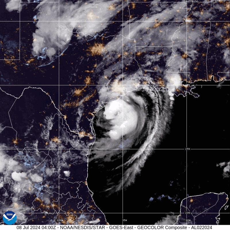
Hurricane Beryl – GeoColor: NOAA
As of 7:00 a.m. EDT, the NHC reports that life-threatening storm surge, strong winds, and torrential rainfall are ongoing across eastern Texas. The combination of storm surge and tide is anticipated to cause seasonally dry areas near the coast of Texas, from Mesquite Bay to Sabine Pass, Texas, to be inundated by storm surges of up to seven feet. Officials urge residents of Mesquite Bay to Sabine Pass, Texas should be aware of the ongoing Storm Surge Warning. Additionally, the NHC predicts heavy rainfall between five to 10 inches, with certain areas potentially receiving up to 15 inches, across the Texas Gulf Coast and Eastern Texas as well as portions of Arkansas, Missouri, and Oklahoma. Heavy rainfall is anticipated to cause considerable flash and urban flooding along the Texas Gulf Coast and Eastern Texas. Damaging hurricane-force winds are also expected along the coast of Texas, as a Hurricane Warning is in effect from Mesquite Bay to Port Bolivar, Texas.
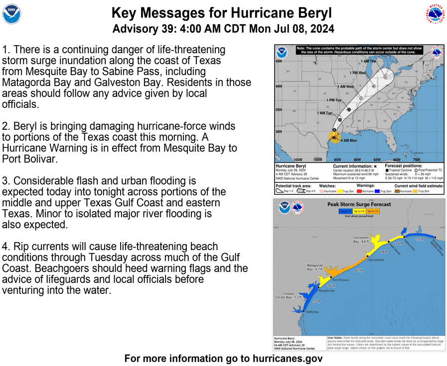
Key Messages for Hurricane Beryl: NWS
As of 8:00 a.m. EDT, more than 100,000 Texas customers were without power. Additionally, there is a possibility for scattered tornadoes across the upper Texas coast, east Texas, Arkansas, and Louisiana, as rain bands stretch across the area – tropical systems often produce tornados embedded in rain bands. Ahead of Beryl’s landfall, on July 7, Acting Governor of Texas Dan Patrick issued a disaster declaration for 121 counties throughout the State. More than 2,500 responders and 1,200 assets have been deployed to support the State’s response efforts to the projected impacts of Hurricane Beryl.
⚠❗Storm surge is often the greatest threat to life and property from a #hurricane. https://t.co/HmRUeJjf23 #WeatherReady pic.twitter.com/N2oFVb5bYT
— National Weather Service (@NWS) July 7, 2024
X: NWS
Hurricane Beryl brings potential life-threatening storm surge to many coastal communities. NOAA provides information on storm surge warnings and storm surge watches to help individuals be better prepared for potential hazardous situations. The Federal Emergency Management Agency (FEMA) provides guidance to individuals preparing for, experiencing, or affected by hurricanes. Additionally, FEMA encourages individuals to take the necessary precautions and prepare for flash flooding. Flash floods can develop with little to no warning, quickly changing the surrounding area. FEMA suggests individuals seek higher ground, avoid walking or driving in flood waters, and heed the warnings of local authorities. Over the coming days and weeks, Hagerty’s Blog Team will continue to provide guidance on making effective preparations for long-term recovery, as well as continuing our situational updates.
STAY UPDATED AND LEARN MORE HERE:
- Remember, Ready.gov provides information on how to prepare for a storm and how to keep you and your family safe.