According to the National Oceanic and Atmospheric Administration’s (NOAA) National Hurricane Center (NHC), as of 8:00 a.m. Eastern Daylight Time (EDT), Hurricane Debby has made landfall near Steinhatchee, Florida, along the coast of Florida’s Big Bend as a Category (Cat) 1 hurricane. Additionally, the NHC reports three tropical storms, Carlotta, Daniel, and Emilia, in the Eastern Pacific, none of which are predicted to cause impacts on land.
Debby’s current maximum sustained winds are estimated up to 75 miles per hour (mph) and extend outward up to 140 miles as it tracks North at 12 mph. Hurricanes in the United States (US) are categorized according to the Saffir-Simpson Scale based on their wind speeds, with a Cat 1 reflecting 74 to 95 mph winds and a Cat 5 indicating hurricanes with wind speeds of 157 mph or higher. The NHC estimates that with Cat 1 strength at landfall, dangerous winds will produce some damage, including roof and siding damage to well-built homes, large tree branches to snap, and power outages from extensive damage to power lines and poles, possibly lasting several days.
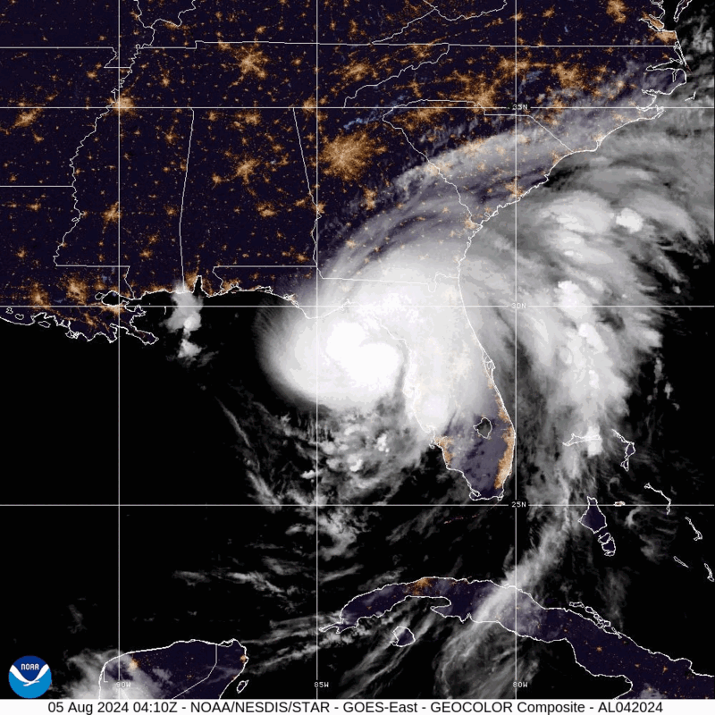
Hurricane Debby – GeoColor: NOAA
As of 8:00 a.m. EDT, the NHC reports that extreme rainfall is forecasted to result in catastrophic flooding across Florida, Georgia, North Carolina, and South Carolina. The combination of storm surge and tide is anticipated to cause seasonally dry areas near the coast of Florida, from Indian Pass to Bonita Beach, Florida, to be inundated by storm surges of up to 10 feet. Officials urge residents of Indian Pass to Bonita Beach, Florida, to be aware of the ongoing Storm Surge Warning. Additionally, the NHC predicts heavy rainfall between six and 12 inches, with certain areas potentially receiving up to 18 inches, across Central and Northern Florida, as well as Central and Northeastern North Carolina, as well as up to 30 inches in portions of Georgia, North Carolina, and South Carolina. Damaging hurricane-force winds are also expected along Florida’s Big Bend, as a Hurricane Warning is in effect from Yankeetown to Indian Pass, Florida.
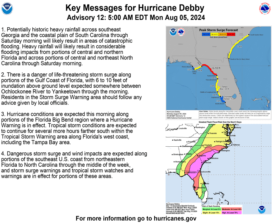
Key Messages for Hurricane Debby: NWS
As of 9:00 a.m. EDT, more than 250,000 Florida customers were without power. Additionally, there is a possibility for scattered tornadoes across central and northern Florida, southeastern Georgia, and South Carolina, as rain bands stretch across the area — tropical systems often produce tornadoes embedded in rain bands. Ahead of Debby’s landfall, on August 2, Governor of Florida Ron DeSantis issued a state of emergency for 61 counties throughout the State. Up to 3,000 National Guardsmen and 17,000 Florida Division of Emergency Management (FDEM) linemen have been deployed to support the State’s response efforts to the projected impacts of Hurricane Debby.
Slow-moving Debby is likely to generate catastrophic flooding from northern FL and along the GA/SC coasts. Up to 30 inches of rainfall in an already flood-prone region will lead to widespread impacts. Have a plan to get to safety if and when floodwaters rise. pic.twitter.com/9NmYDBrzUZ
— National Weather Service (@NWS) August 5, 2024
X: NWS
Hurricane Debby brings a potential life-threatening storm surge to many coastal communities. NOAA provides information on storm surge warnings and storm surge watches to help individuals be better prepared for potential hazardous situations. The Federal Emergency Management Agency (FEMA) provides guidance to individuals preparing for, experiencing, or affected by hurricanes. Additionally, FEMA encourages individuals to take the necessary precautions and prepare for flash flooding. Flash floods can develop with little to no warning, quickly changing the surrounding area. FEMA suggests individuals seek higher ground, avoid walking or driving in flood waters, and heed the warnings of local authorities. Over the coming days and weeks, Hagerty’s Blog Team will continue to provide guidance on making effective preparations for long-term recovery, as well as continuing our situational updates.
Stay Updated and Learn More:
Remember, Ready.gov provides information on how to prepare for a storm and keep you and your family safe.