According to the National Oceanic and Atmospheric Administration’s (NOAA) National Hurricane Center (NHC), as of 11:00 a.m. Eastern Daylight Time (EDT), a Hurricane Warning is in effect for communities from Anclote River to Mexico Beach, Florida, as Hurricane Helene approaches Florida’s Big Bend. The NHC forecasts that Helene is expected to strengthen throughout the day and is projected to make landfall as a major hurricane along the coast of Florida’s Big Bend on the evening of Thursday, September 26, or in the early morning of Friday, September 27.
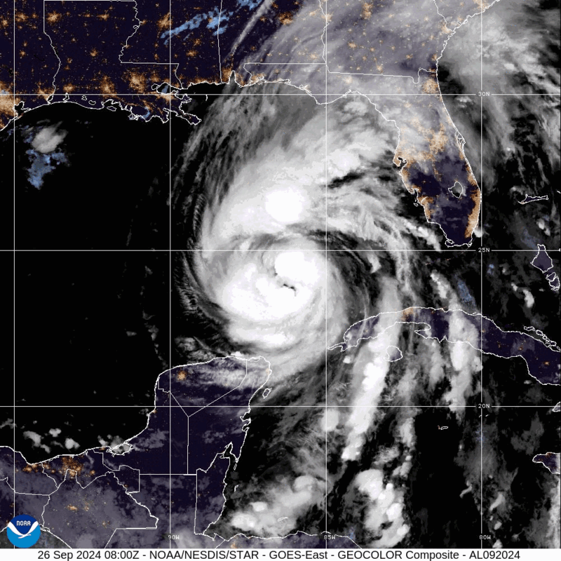
At 11:00 a.m. EDT, the NHC reported that Hurricane Helene was in the Gulf of Mexico, about 255 miles Southwest of Tampa, Florida, and 290 miles South of Apalachicola, Florida. The storm’s maximum sustained winds are near 105 miles per hour (mph) with hurricane force winds extending outward up to 60 miles and tropical storm force winds extending outward up to 345 miles from the center.
Hurricane Helene – GeoColor: NOAA
Storm’s Impact and Pre-Landfall Warnings
In anticipation of Helene’s landfall, Storm Surge Warnings have been issued for communities across the Western coast of Florida as the NHC warns of life-threatening storm surge. Additionally, mandatory evacuations are in place for at least 15 counties along the Western coast of the state, spanning from Apalachicola to Charlotte County, Florida. Voluntary evacuations are also in place for eight counties, with local officials recommending that people living in mobile homes, “substandard housing,” or flood-prone areas evacuate to a shelter or other safe locations.
As of 11:00 a.m. EDT, the NHC has classified Hurricane Helene as a Category (Cat) 3 hurricane and cautions that the storm is likely to produce potentially catastrophic winds within the eyewall. Communities along the coasts of Alabama, Western Florida, Southeastern Louisiana, and Mississippi will likely begin to experience impacts from Helene throughout Thursday, September 26, prior to the storm’s landfall. Officials forecast that pre-landfall impacts will include tropical-storm-force winds of at least 39 mph, tornadoes, and flash flooding. In a statement released on Tuesday, September 24, the Federal Emergency Management Agency (FEMA) urged residents and visitors of the Gulf Coast to prepare for the possibility of a major storm. Areas within Florida’s Big Bend Coast around the Apalachee Bay, where Hurricane Helene is expected to make landfall, have a 30 to 90 percent chance of experiencing hurricane-force winds of at least 74 mph.
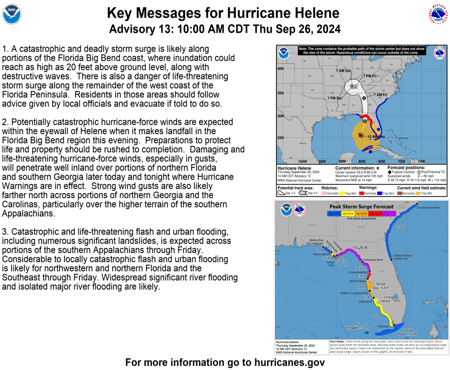
Other impacts include dangerous storm surge along portions of the Big Bend Coast of Florida. Storm surge is the rise in seawater levels during a storm and is measured by the additional height of water above normal levels. Storm surge is likely to cause flooding in normally dry coastal areas as rising waters move inland. Coastal regions around Hurricane Helene’s predicted landfall zone, between Carrabelle, Florida and Suwannee River, Florida, are predicted to receive between 15 to 20 feet of storm surge while communities from Carrebelle to Apalachicola, Florida and Suwannee River to Chassahowitzka, Florida, are predicted to receive 10 to 25 feet of storm surge. Storm surge may also reach up to eight to 12 feet between Chassahowitzka and Anclote River, Florida. Tornado risks are also present throughout Florida, as at least 14 different tornado warnings were issued on Thursday, September 26.
As Hurricane Helene tracks inland, officials predict that the storm will produce significant rainfall of six to 12 inches across portions of the Southeastern United States (US) and Southern Appalachians, with the possibility of isolated totals of up to 20 inches in portions of Western North Carolina. NOAA’s Weather Prediction Center (WPC) issued a rare “high risk” flood outlook for communities from Northeast Georgia to Western North Carolina. Heavy rainfall is likely to result in severe flash and urban flooding as well as river flooding. The high volume of rainfall also creates an increased risk for landslides in the mountainous areas of the Southern Appalachian, as on Wednesday, September 25, areas received heavy rainfall from a separate weather system.
Government Response and Preparations
Ahead of the storm’s landfall, in a press conference on Thursday morning, September 26, Florida Governor Ron DeSantis noted that the effects from Hurricane Helene will be widespread. Additionally, in anticipation of Helene’s landfall, on Tuesday, September 24, Governor DeSantis declared a state of emergency for 61 counties across the state. Additionally, on September 23, President Biden approved an emergency declaration for Florida in response to Helene, enabling federal assistance to support state and local response and recovery efforts. Governor DeSantis also cautioned that communities outside of the direct cone of impact will still likely experience risks, particularly from storm debris, and should plan to take precautions. Pre-landfall hazards from Hurricane Helene have already begun to reach areas in Southern Florida, including St. Petersburg, near Tampa, Florida. Energy providers such as Duke Energy Florida and Florida Power & Light (FPL) have already begun mobilizing restoration crews and bringing in thousands of additional reinforcements from other states to assist in restoration.
Key Messages for Hurricane Helene: NWS
Officials throughout the storm’s forecasted path have already begun to take measures to prepare for heavy wind and rain, as well as flooding potential. In Georgia, Governor Brian Kemp issued a state of emergency on Wednesday, September 25, for all 159 counties in the state and advised the Georgia Emergency Management and Homeland Security Agency (GEMA/HS) to activate the State Operations Center (SOC). GEMA/HS has issued updates for residents of Georgia, including information on where to shelter and updates on the storm. Governors Henry McMaster of South Carolina and Roy Cooper of North Carolina also issued a state of emergency for their respective states on Wednesday, September 25, which allowed for the mobilization of resources in the event of high winds, heavy rains, and flooding impacts. Further north, Virginia Governor Glenn Youngkin issued a state of emergency on Wednesday, September 25, in preparation for the storm’s potential impacts. Each of these states’ governor’s office has advised residents to stay alert and informed on hurricane preparedness activities through Ready.gov in addition to following local and state advisories.
According to Hagerty’s Director of Response, Lee Mayfield, “Declaring a state of emergency allows state and local jurisdictions to get ready, look at all of the rules and regulations, and maybe cut some red tape to move as quickly as they can to respond and keep the public safe. Those states of emergencies are important… and how they unfold makes a big difference in how the response effort.” Watch his full interview with FOX Weather here.
The NHC warns that Hurricane Helene brings potential life-threatening storm surge to many coastal communities. NOAA provides information on storm surge warnings and storm surge watches to help individuals be better prepared for potential hazardous situations. FEMA provides guidance to individuals preparing for, experiencing, or affected by hurricanes. Additionally, FEMA encourages individuals to take the necessary precautions and prepare for flash flooding. Flash floods can develop with little to no warning, quickly changing the surrounding area. FEMA suggests individuals seek higher ground, avoid walking or driving in flood waters, and heed the warnings of local authorities.
#Helene may bring heavy rains & cause flash flooding in your area.
Never drive through floodwaters. Almost half of all flash flood deaths happen in vehicles.
Protect yourself & others: https://t.co/5WQUDCC70W pic.twitter.com/eQfyQJC0AO
— Readygov (@Readygov) September 25, 2024
X: Ready.gov
Additionally, the NHC Storm Prediction Center (SPC) warns of potential tornadoes throughout Thursday afternoon through Friday in parts of Florida, Georgia, South Carolina, and Georgia. FEMA encourages individuals to take the necessary precautions and prepare for tornadoes. Tornadoes can appear suddenly, destroy buildings, flip cars, and create deadly flying debris. FEMA suggests individuals under Tornado Warnings seek shelter right away.
Over the coming days and weeks, Hagerty’s Blog Team will continue to provide guidance on making effective preparations for long-term recovery, as well as continuing our situational updates.
Stay Updated and Learn More
Remember, Ready.gov provides information on how to prepare for a storm and keep you and your family safe.