TUESDAY, NOVEMBER 8, 2022 AS OF 12:00 PM EST
According to the National Oceanic and Atmospheric Administration (NOAA) National Hurricane Center (NHC), Tropical Storm Nicole has been declared a large tropical cyclone with storm-force winds extending outward up to 380 miles and maximum sustained winds of 50 miles per hour (mph). As of 10:00 a.m. Eastern Standard Time (EST), Tropical Storm Nicole was located about 350 miles northeast of the Northwestern Bahamas and moving west at nine mph. Due to the size of the storm and the uncertainty of its path, the NHC discourages focus on the storm’s exact track as anticipated hazards are expected to extend outside of the forecast cone. A hurricane warning is currently in effect for the Abacos, Berry Islands, Bimini, and Grand Bahama Island in the Northwestern Bahamas, where dangerous storm surge and hurricane conditions are expected on Wednesday, November 9. According to National Emergency Management Agency (NEMA) Director Stephen Russell, 28 shelters will be activated in Grand Bahama and Abaco today as officials begin evacuating local residents from the Grand Cay and Sweetings Cay areas.
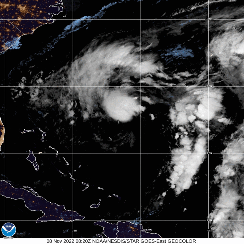 Subtropical Storm Nicole- GeoColor: NOAA
After exiting the Bahamas, Tropical Storm Nicole is forecast to make its second landfall along the southeast and east-central coast of Florida as a hurricane or strong tropical storm Wednesday night, November 9. As the exact track of the storm remains uncertain, hurricane warnings have been issued along the east coast of Florida from Boca Raton to the Flagler/Volusia County Line. On Monday, November 7, Florida Governor Ron DeSantis issued an Executive Order to declare a state of emergency for 34 counties in the potential path of the storm, where projected impacts include heavy rainfall, strong winds, prolonged coastal flooding, life-threatening surf and rip current conditions, and storm surge levels of up to five feet above ground level. The NHC warns that severe flash and urban flooding is likely along the St. Johns River, with possible flooding risks extending in Southwest Georgia and portions of South Carolina Thursday, November 10.
MIDWEST STORM SYSTEM
On Saturday, November 5, several Midwest states experienced a strong storm system, which included thunderstorms and intense wind gusts. Officials in Chicago issued high wind warnings, and gusts exceeded 60 mph in some areas. National Weather Service (NWS) Chicago reported peak winds across the region ranging from 40 to 77 mph, including 77 mph at Dupage Airport and 60 mph at Chicago O’Hare Airport. NWS Chicago confirmed that a tornado scoring an EF-0 on the Enhanced Fujita (EF) Scale of Tornado Intensity touched down in Kendall and Kane counties around 10:00 a.m. EST on Saturday, November 5. The tornado traveled approximately four miles and produced wind gusts estimated at 80 mph. In West Michigan, winds reached 64 mph in Kalamazoo and 53 mph in Grand Rapids. NWS Northern Indiana reported gusts of 72 mph in Roann and 66 mph at South Bend International Airport.
Here are some of the highest recorded wind gusts from across the region since early this morning. We’ve received many reports of damage from these winds. #ilwx #INwx pic.twitter.com/xAJCgqdk4Z
— NWS Chicago (@NWSChicago) November 5, 2022
Twitter: NWS Chicago
The storm system caused widespread power outages across the region, and 170,000 customers were without power as of 4:00 p.m. EST on Saturday, November 5. According to the latest update by PowerOutage.us, around 10,000 customers in the Great Lakes region remain without power. Additionally, the Chicago region saw several delays and disruptions at airports and train systems due to halted service. The severe weather also caused infrastructure damage in the Chicago area, including lifting off the roof of an apartment building in Elk Grove Village, Illinois. No injuries have been reported as the result of the damaging winds or EF-0 tornado.
Eastern Florida & coastal Georgia: Storm surge — fast & life-threatening flooding — is possible due to #Nicole. Have a plan.
Follow @NHC_Surge for latest updates
Download the FEMA App: https://t.co/i3YpwYU8PV
Sign up for local warnings & alerts: https://t.co/DOS4888Et5 pic.twitter.com/zDNYGz18cJ— Readygov (@Readygov) November 7, 2022
Twitter: Readygov
The NWS offers advice and guidance for those about to experience, currently impacted by, or previously affected by tropical storms and hurricanes. Individuals at risk are encouraged to secure their homes, remain up-to-date with information from their local NWS office and local government/emergency management office, and follow guidance issued by local officials. Storm surges that cause major flooding are especially dangerous and life-threatening impacts of major storms, so it is crucial to know how to stay safe during a flood. Additionally, the Federal Emergency Management Agency (FEMA) encourages individuals to take the necessary precautions and prepare for dangerous storms. It’s imperative to remember that flash floods can occur during storms with little to no warning, quickly changing the surrounding area. FEMA suggests individuals seek higher ground, avoid walking or driving in flood waters, and heed the warnings of local authorities. FEMA also reminds individuals experiencing flooding to “Turn Around, Don’t Drown!” – six inches of moving water is all it takes to knock a person down, and vehicles can be swept away by just one foot of water. Major flooding also increases the likelihood of landslides and debris flow, which may pose severe risks to human life, land, and property. FEMA urges individuals to stay alert to instructions from their local emergency management agency, and to evacuate the area and move uphill as quickly as possible if in the path of a landslide. It is important to understand the warning signs, risks, and safety guidance associated with both fast- and slow-moving landslides.
The Hagerty Blog Team will continue providing information and updates.
STAY UPDATED AND LEARN MORE HERE:
- Remember, Ready.gov provides information on how to prepare for a storm and how to keep you and your family safe.
- Understanding the meaning of hurricane maps – a NY Times Opinion Piece: Those Hurricane Maps Don’t Mean What You Think They Mean