THURSDAY, AUGUST 19, 2021 AS OF 1:00 PM EST
With continued heat and drought conditions in the western United States (US) this summer, wildfires continue to rage; the National Interagency Fire Center (NIFC) reports that 104 large fires are burning across 12 states. Collectively, these fires account for 2.56 million acres of land burned. The largest fires are currently burning in Northern California. The Dixie Fire, which originally started burning on July 13, 2021 in Northern California, has burned more than 660,000 acres to date. Residents continue to be evacuated from the region as over 6,000 fire personnel fight to contain the fire in Butte and Plumas counties. 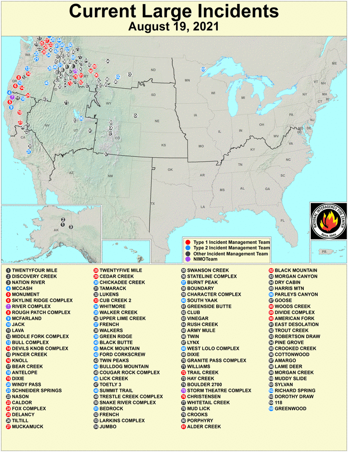
Current Large Fire Incidents in the US: USDA Forest Service
According to California Public Radio, 31,000 Californians statewide are under evacuation orders. More broadly, as of August 17, 2021, 11 of the 58 counties in California are under a state of emergency due to wildfires. In addition to the Dixie Fire, emergency orders and evacuations have been issued in response to the Caldor Fire (El Dorado County), the Glen Fire (Yuba County), the McFarland and Monument Fires (Trinity County), and the Antelope and Lava Fires (Siskiyou County). The most recent fire, the Caldor Fire, which began burning on August 14, has no containment with over 65,500 acres burned.
Pacific Gas and Electric (PG&E), California’s utility provider for Northern California, has issued guidance for outages caused by unsafe weather and fire conditions. This week, 13 counties were impacted by public safety power shutoffs (PSPS), including Butte, Glenn, Mendocino, Napa, and Yolo counties. To maintain essential services, the company has opened community resource centers with capacity for charging devices, Wi-Fi, and medical device support. In the event of an evacuation, residents are requested to utilize community centers in non-impacted counties.
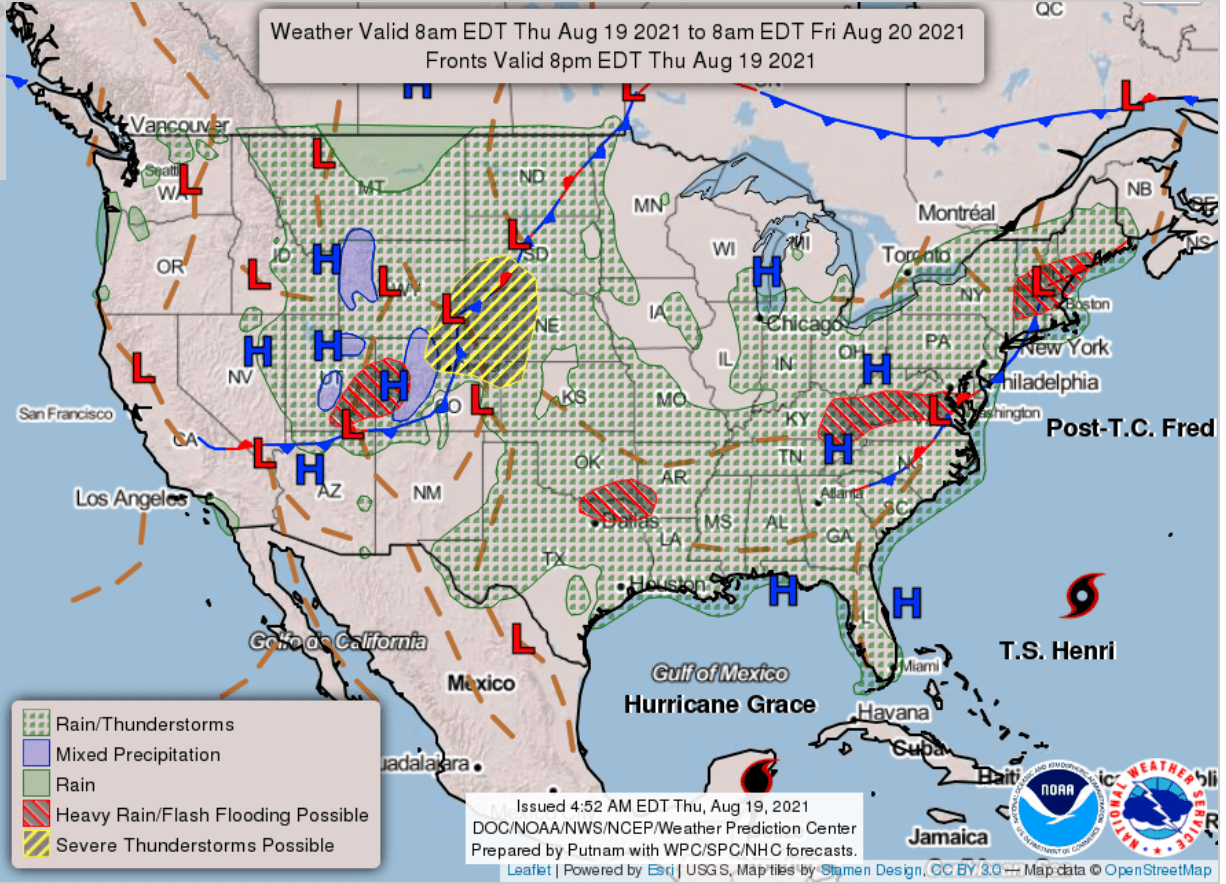
National Forecast Chart: Weather Prediction Center
The National Oceanic and Atmospheric Administration (NOAA) National Hurricane Center (NHC) has reported Tropical Storm Henri is approximately 490 miles southeast of Cape Hatteras, North Carolina, moving westward over the western Atlantic Ocean at 10 miles per hour (mph). The NHC cautioned the motion is anticipated to continue throughout Thursday night, with a turn toward the northwest expected on Friday as it intensifies to a hurricane. On Saturday and Sunday, Henri is expected to switch directions and accelerate north and northeast. Henri is forecast to be near southern New England on Sunday and Monday. Currently, tropical storm force winds reach outward up to 80 miles from the center of Henri, with maximum sustained winds remaining close to 70 mph.
The Weather Prediction Center (WPC) reported Post-Tropical Cyclone Fred is roughly 50 miles west-northwest of Albany, New York, moving east-northeast at 15 mph with maximum sustained winds of 25 mph. The cyclone is moving towards central New England, and the NHC has issued flash flood watches for parts of New York and central New England. Fred is forecast to bring one to three inches of rain throughout eastern New York and New England, with isolated maximum storm totals of five inches through Thursday night. The NHC stressed the rainfall could result in flash, urban, small stream, and isolated river flooding. The flood risk is anticipated to minimize by early Friday.
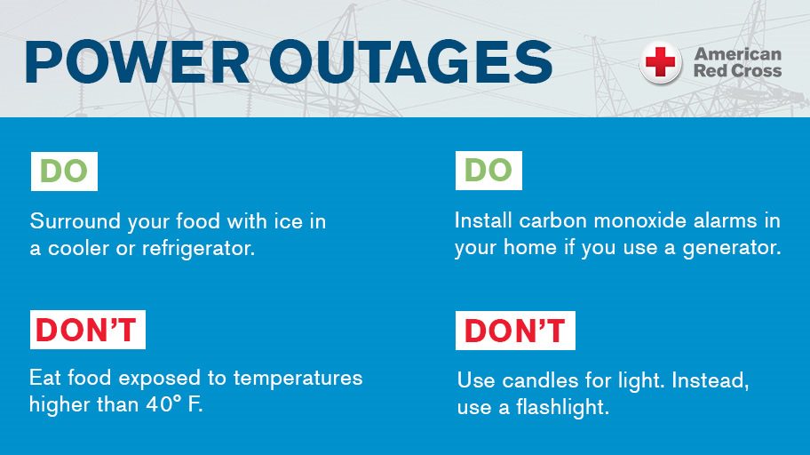
Power Outages Safety Steps: American Red Cross
As the US experiences extreme heat, drought, and the consistent threat of wildfires, there is an increased risk of short- or long-term power outages impacting homes and businesses. It is important for individuals to be prepared for such disruptions should they need to conserve energy or lose power unexpectedly. Ready.gov offers guidance for protection during a power outage, including preparing backup plans for powered medical devices, refrigerated medicines, and food storage; as well as having alternative power sources for other important technology, like cellphones. Additionally, the California Department of Forestry and Fire Protection (CAL FIRE) provides useful preparedness tips like figuring out how to manually open automatic garage doors, keeping gas tanks at least half full in vehicles, and ensuring backup power generators are properly installed and operational. Residents should continue to pay close attention to Flex Alerts or other notifications from local and state officials that urge consumers to conserve energy in order to help avoid power disruptions. NOAA’s National Weather Service (NWS) has provided a list by state and county of red flag warnings and air quality alerts in decreasing order of severity.
The Hagerty Blog Team will continue providing information and updates on current events and disasters impacting the nation. Visit Disaster Discourse for the latest information.
RELATED STORIES
- Remember, Ready.gov provides information on how to prepare for wildfires and how to keep you and your family safe, including evacuation planning, preparing a go-bag, and staying up-to-date on warnings and notices.
- FEMA America’s PrepareAthon: How to Prepare for a Wildfire.
- The Los Angeles Times regularly updates tracking of California Wildfires: California Wildfires Map.
- The National Fire Protection Association provides wildfire preparedness tips: link.
- Marin County provides a wildfire evacuation checklist: link.
- FEMA provides an informational video about how to be prepared for wildfires: link.
- Understanding the meaning of hurricane maps – a NY Times Opinion Piece: Those Hurricane Maps Don’t Mean What You Think They Mean