THURSDAY, JULY 11, 2024, AS OF 2:00 PM EST
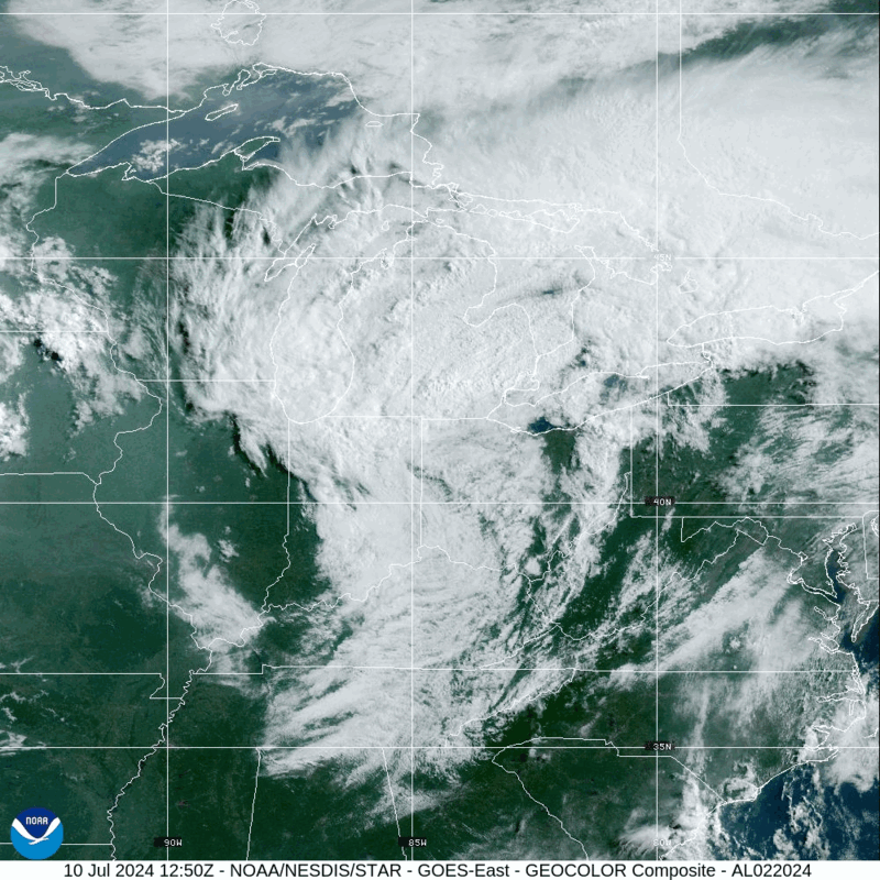
According to the National Oceanic and Atmospheric Administration’s (NOAA) National Hurricane Center (NHC), Post-Tropical Cyclone Beryl made landfall along the Southeastern coast of Texas on Monday, July 8, as a Category (Cat) 1 hurricane. The system brought heavy rainfall, flooding, and tornadoes to communities across the South, resulting in at least eight fatalities and widespread power outages. After impacting the South, Beryl downgraded to a Post-Tropical Cyclone and continued to weaken as it traveled Northeast towards the Mid-Atlantic and New England. Additionally, over Independence Day weekend, from Friday, July 5, to Sunday, July 7, hundreds of fires ignited across California, fueled by the ongoing heat wave and extremely dry conditions throughout the state. As of Thursday, July 11, there are 74 large active wildfires in the United States (US), which have collectively burned 681,569 acres across 13 states. Of these, Alaska is experiencing the bulk of the active fires, with 35 currently burning, followed by California, where nine are actively impacting the state.
Post-Tropical Cyclone Beryl – GeoColor: NOAA
Post-Tropical Cyclone Beryl
Beryl, the second named storm of the 2024 Atlantic Hurricane Season, made history on Tuesday, July 2, when it strengthened to a Cat 5 hurricane, making it the earliest Cat 5 hurricane on record. Beryl first made landfall in the Caribbean islands as a Cat 4 Hurricane on Monday, July 1, impacting Grenada, then Jamaica on Wednesday, July 3, with winds up to 165 miles per hour (mph). Upon making landfall in Matagorda, Texas, on Monday, July 8, Beryl was identified as a Cat 1 storm with sustained winds of 80 mph, bringing damaging winds and storm surge to the southeastern Texas coast. After its landfall, Beryl was downgraded to a Tropical Storm, then to a Post-Tropical Cyclone on Tuesday, July 9, all while continuing to produce significant hazards, including tornadoes, storm surge, flash flooding, and downed powerlines, in communities across the Southeast and Mississippi and Ohio Valley.
League City crews are checking all areas for rain and wind damage from Beryl. If you see a downed power line, traffic light outage, tree limbs blocking roadways, or flooded roadways, call Public Works at 281-554-1086.
Only call 911 if there is a fire or medical emergency. pic.twitter.com/ipw8emzxoL— League City, Texas (@LeagueCityTX) July 8, 2024
By Wednesday, July 10, the risk of flash flooding and tornadoes had been extended to northern Mid-Atlantic and New England states as Beryl continued moving northeast across the US. The NWS confirmed that on Tuesday, July 9, a tornado ranking a three out of five on the Enhanced Fujita (EF) scale impacted Mt. Vernon, Indiana, with wind speeds of up to 140 mph. Three confirmed tornadoes also impacted the state of New York on Wednesday, July 10, prompting a state of emergency for the town of Eden, New York.
Additionally, according to PowerOutage.us, an estimated 1.3 million Texas residents remain without power as of Thursday, July 11, with the greatest concentration of outages in Brazoria, Polk, Trinity, and San Jacinto counties. In advance of Beryl’s landfall, acting Texas Governor Dan Patrick called for a disaster declaration on Saturday, July 6, and President Biden approved federal disaster assistance to the state of Texas on Wednesday, July 10. This Federal Emergency Management Agency (FEMA) designation allows for state, tribal, and eligible local governments to access resources to rebuild as debris removal and emergency recovery efforts are underway. FEMA urges residents in impacted areas to follow Ready.gov best practices in response to Beryl and be aware of changes via communications from state and local emergency agencies.
Remember, historically almost half of all lives lost during a hurricane are AFTER it passes. Use caution and remain vigilant during the clean-up phase of #Beryl. More info on the storm: https://t.co/tW4KeGe9uJ pic.twitter.com/PpQfOfU61S
— National Hurricane Center (@NHC_Atlantic) July 8, 2024
X: NHC
California Wildfires
Over the past several weeks, an increasing number of wildfires have ignited across the state of California, prompting concern about the threat of an especially active wildfire season. According to the California Department of Forestry and Fire Protection (CAL FIRE), so far this year, 3,543 wildfires have burned 207,415 acres across California. For comparison, 3,005 wildfires burned 10,080 total acres in all of 2023.
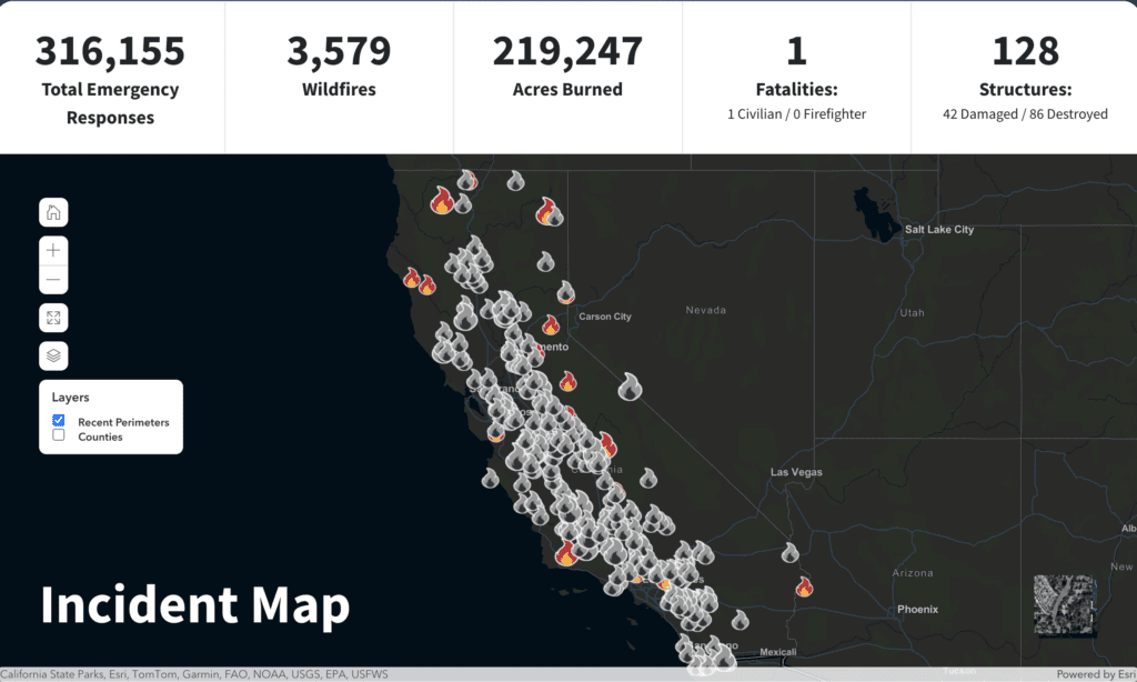
2024 Incident Map: CAL FIRE
On Friday, July 5, the Lake Fire started in the Los Padres National Forest, approximately 50 miles north of Santa Barbara, California. The Santa Barbara County Sheriff’s Department reports that roughly 440 people have been forced to evacuate, and over 1,100 remain under evacuation warnings. As of Thursday, July 11, the Lake Fire has burned 34,015 acres, making it the state’s largest wildfire this year. As of Thursday, July 11, the fire is 16 percent contained, with over 3000 assigned personnel responding. So far, four injuries have been reported, along with damage to four structures.
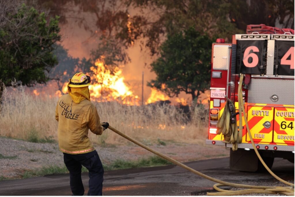
Thompson Fire: CAL FIRE
Additionally, other major fires, including the Shelly, Vista, and Thompson Fires, have forced evacuations and threatened damage to nearby communities. On Wednesday, July 3, the Shelly Fire erupted in the Marble Mountain Wilderness within Siskiyou County, California, and has since burned 9,234 acres as of Thursday, July 11. Hot, dry conditions and access issues have posed challenges to the firefighting crews as the fire continues to spread and threaten residences and tribal lands in the vicinity. The Vista Fire was first reported on Sunday, July 7, in the San Bernardino National Forest, prompting the closing of and evacuation orders for Mt. Baldy Ski Resort. According to CAL FIRE, the Vista Fire has burned 2,700 acres and currently sits at zero percent containment as of Wednesday, July 10. Another major wildfire that has impacted the state in recent weeks was the Thompson Fire in Butte County, which is now 100 percent contained after burning 3,789 acres between Tuesday, July 2, and Monday, July 8. The incident prompted California Governor Gavin Newsom to declare a state of emergency on Wednesday, July 3, in conjunction with evacuation orders near the City of Oroville that affected 28,000 people. The final Incident Update from CAL FIRE on Monday, July 8, reported a total of 26 structures destroyed, eight structures damaged, and two firefighter injuries.

Wireless Emergency Alerts (WEA): NWS
Flood and Wildfire Safety
FEMA encourages individuals to take the necessary precautions and prepare for flash flooding. Flash floods can develop with little to no warning, quickly changing the surrounding area. FEMA suggests individuals seek higher ground, avoid walking or driving in flood waters, and heed the warnings of local authorities.
Additionally, wildfires can occur anywhere in the country at any time, spreading quickly and unpredictably. FEMA urges individuals and communities to take preventive measures to protect their property and loved ones in the event of a wildfire emergency.
- Set up real-time, local alerts in the FEMA app and determine other ways that you can receive time sensitive notifications to keep you safe.
- Make (and practice!) an emergency plan to include how to quickly access your disaster supplies kit, the safest evacuation routes, and the needs of pets under your care.
- Take time to review, update, and ensure safe storage of important documentation related to your household’s or business’ financial, legal, insurance, medical, and other personal information.
Over the coming days and weeks, Hagerty will continue to provide guidance on making effective preparations for long-term recovery, as well as continuing our situational updates.