MONDAY, AUGUST 21, 2023, AS OF 12:00 PM EST
According to the National Oceanic and Atmospheric Administration (NOAA) National Hurricane Center (NHC), Post–Tropical Cyclone Hilary in the Southwest United States (US) brought five to 10 inches of rain to southern California and Nevada from Sunday, August 20 to Monday, August 21. The storm, once a Category (Cat) 4 Hurricane, has been downgraded to a post-tropical cyclone and is moving north-northeast at 29 miles per hour (mph) across Central/Northern Nevada as of 2:00 a.m. Pacific Daylight Time (PDT). Sustaining wind speeds of up to 35 mph, the NHC expects the storm to produce an additional two to four inches of rainfall across portions of southern California and Nevada. Hazards of this storm include life-threatening flash flooding, landslides, mudslides, and debris flows. Strong and gusty winds are expected to persist across portions of the western US today, with gust speeds of up to 45 mph.
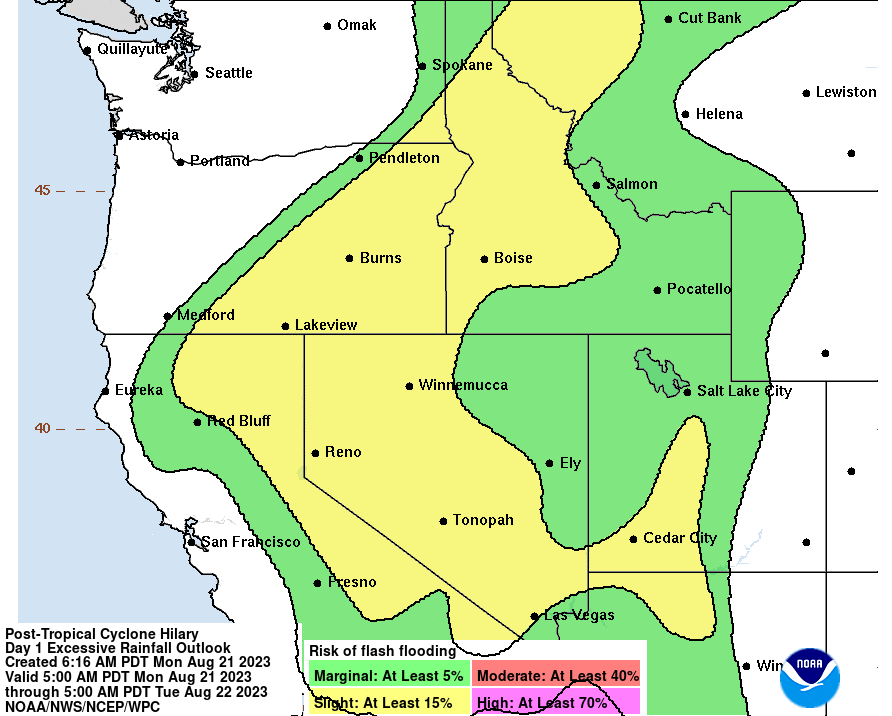
Flash Flooding Outlook for Post-Tropical Cyclone Hilary: NHC
As Southern California dealt with the impact of Post-Tropical Cyclone Hilary, on Sunday, August 20, at 2:41 p.m. PDT, a magnitude (M) 5.1 earthquake occurred 7 kilometers (km) southeast of the City of Ojai, California, at a depth of 4.8 km. Officials reported that the earthquake occurred on the Sisar fault system causing “moderate” shaking intensity according to the Modified Mercalli Intensity (MMI) scale, with the most significant shaking in Ojai and light shaking in the surrounding cities of Ventura, Oxnard, and Camarillo. Southern California residents received an early warning notification on the MyShake app prior to experiencing the temblor. An update at 5:00 p.m. PDT on August 20 by the Ventura County (VC) Office of Emergency Services (OES) indicated that there were more than 30 aftershocks since the original events–noting that it is common for aftershocks to occur for several days or even weeks following an earthquake of that magnitude–but reported no injuries and no major structural damage to any buildings. According to the Southern California Seismic Network (SCSN), there were 19 recorded foreshock events in the three days leading up to the M5.1 earthquake, including an M2.5 earlier on the day of the event. Since records began in 1932, SCSN reports that there have been only five earthquakes of M4 or greater within 10 km of the M5.1 event on August 20. Earthquake scientists, including Dr. Lucy Jones, have indicated no correlation between the earthquake and the tropical storm.
Atlantic Hurricane Season
Additionally, in the Atlantic, there are currently three tropical storms and two disturbances. On Sunday, August 20, Tropical Storm Emily formed in the Atlantic Ocean as the fifth named storm of the 2023 Atlantic Hurricane Season. As of August 21, at 5:00 a.m. EST, the NHC has reported that Emily is located roughly 1,165 miles west-northwest of the Cabo Verde Islands with maximum sustained winds of 40 mph as it heads west-northwest at 12 mph. Emily’s path is expected to continue in its current direction over the next couple of days and potentially shift north by the middle part of the week. The system is forecasted to weaken into a post-tropical cyclone by Monday evening, August 21, and is not expected to post any hazards to land.
A second confirmed system, Tropical Storm Franklin, has prompted a tropical storm watch for the Dominican Republic and Turks and Caicos Islands through Tuesday night, August 22. As of August 21, at 8:00 a.m. EST, Franklin is located roughly 235 miles south of the Dominican Republic’s capital city, Santo Domingo, with maximum sustained winds of 50 mph. Forecasters expect Franklin to continue its west-northwestward track before shifting north and increasing intensity. The center of the system is forecasted to approach the southern coast of Hispaniola by Tuesday afternoon, August 22, and produce risks of heavy rain, high winds, storm surge, and potentially life-threatening flash flooding.
The eighth named storm of the Atlantic Hurricane Season, Tropical Storm Gert, is moving west at nine mph with maximum sustained winds of 40 mph as of 5:00 a.m. EST, according to the NOAA NHC. This storm is about 455 miles east-southeast of the Northern Leeward Islands. While the NHC predicts this storm to gradually turn west-northwest by Monday night, August 21, forecasters anticipate the storm to dissipate within the next 24 to 48 hours.

Tropical Storms in the Atlantic-GeoColor: NOAA
Additionally, the NHC has identified two disturbances in the Atlantic carrying moderate to high chances of cyclone formation as of August 21 at 8:00 a.m. EST. The first tropical disturbance, located in the Western Gulf of Mexico, poses an 80 percent chance of storm formation within the next two days. Forecasters anticipate the system to develop into a tropical depression or tropical storm before approaching the coastline of southern Texas and northern Mexico on Tuesday, August 22. In the Eastern Tropical Atlantic, a second disturbance over the Cabo Verde Islands has a 40 percent chance of developing into at least a tropical depression over the next two days. As conditions appear conducive for gradual development, the NHC expects the system to form later this week as it moves west-northwestward across the eastern tropical Atlantic.
Maui Wildfires
In addition, the Island of Maui, Hawai’i, continues its recovery efforts after the catastrophic Maui wildfire, which lasted from August 8 to August 11. According to Maui officials, as of August 21, there are 114 confirmed fatalities, numerous injuries, and an estimated 850 people unaccounted for as a result of the wildfire. Additionally, the County of Maui has extended an Unsafe Water Advisory (UWA) for residents in Lahaina and Upper Kula area. Officials from the Department of Water Supply (DWS) urge residents to use bottled water for all needs as the water remains unsafe for consumption even when treated. On August 18, US Army Pacific released a public statement announcing its support of the disaster, including the deployment of Joint Task Force (JTF) 5-0 and 691 Department of Defense (DOD) personnel in Maui. For further updates throughout the State of Hawaii, residents are encouraged to follow advisories from the Hawai’i Emergency Management Agency’s (HI-EMA) Facebook Page, Maui Emergency Management Agency (MEMA)’s Facebook page, and the Federal Emergency Management Agency’s (FEMA) Hawaii Wildfires Webpage.
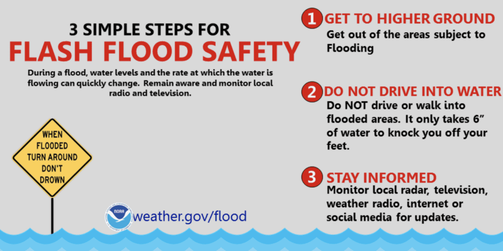
Flood Safety Tips: NWS
FEMA provides guidance to individuals preparing for, experiencing, or affected by hurricanes. Post-Tropical Cyclones and Tropical Storms bring potential for life-threatening storm surge to many coastal and urban communities. Individuals should heed the warnings of local authorities and prepare for tropical storms and severe weather conditions. FEMA also encourages individuals to take the necessary precautions and prepare for flash flooding. Flash floods can develop with little to no warning, quickly changing the surrounding area. FEMA suggests individuals seek higher ground, avoid walking or driving in flood waters, and heed the warnings of local authorities. Individuals under Tornado Warnings should seek shelter right away.
Over the coming days and weeks, Hagerty’s Blog Team will continue to provide guidance on making effective preparations for long-term recovery, as well as continuing our situational updates.
STAY UPDATED AND LEARN MORE HERE:
- Remember, Ready.gov provides information on how to prepare for a storm and how to keep you and your family safe.
- Understanding the meaning of hurricane maps – a NY Times Opinion Piece: Those Hurricane Maps Don’t Mean What You Think They Mean