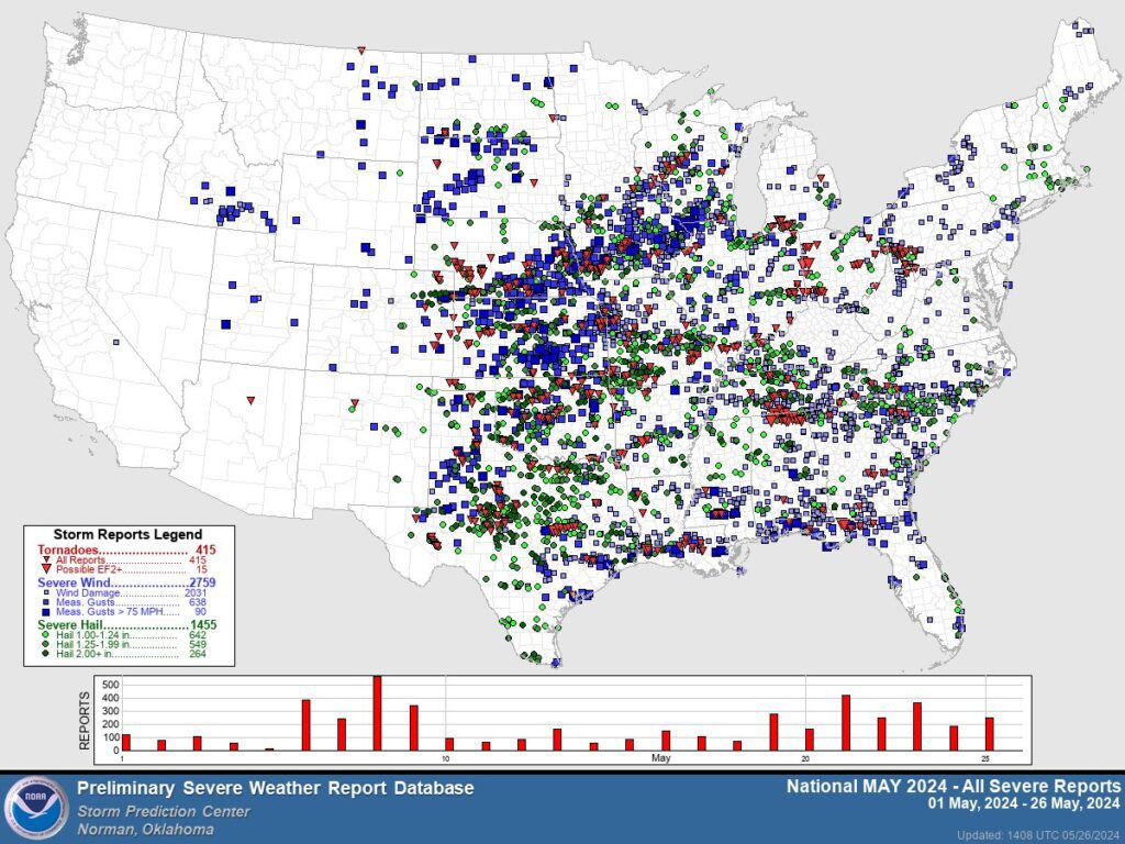
A series of strong thunderstorms and tornadoes impacted large portions of the Central and Southern United States (US) over the Memorial Day holiday weekend from Friday, May 24, to Sunday, 26. On Sunday, May 26, there were approximately 804 preliminary reports of severe weather across 20 states, making Sunday, May 26, the most active severe storm day of 2024. The National Weather Service (NWS) issued five tornado emergencies in Kentucky and Texas over the weekend and over 100 tornado warnings on Sunday, May 29. The severe storms caused a total of 26 fatalities across Alabama, Arkansas, Kentucky, Missouri, North Carolina, Oklahoma, Texas, and Virginia. According to a preliminary severe weather report from the NWS Storm Prediction Center (SPC), there were 80 tornado reports, 845 high-wind reports, and 290 hail reports across the US throughout the weekend of May 24 to 26.
2024 Annual Preliminary Report Summary: NWS SPC
As severe storms continued eastward on Monday, May 27, over 70 million people were under a risk level two out of five, indicating scattered severe thunderstorms were possible, prompting thunderstorm warnings from Wyoming to Washington, DC. The night of Saturday, May 25, brought the most severe weather, and heavily impacted parts of Arkansas, Kentucky, Oklahoma, and Texas.
In Texas, powerful thunderstorms produced at least one confirmed tornado and resulted in seven confirmed fatalities and roughly 100 injuries. Extreme weather continued in Texas through Tuesday, May 28, as cleanup efforts began after the weekend’s severe weather. Nearly 400,000 customers remain without power as of Wednesday afternoon, May 29. Governor Greg Abbott amended a severe weather disaster declaration to add 106 counties to an existing severe weather disaster declaration issued on April 30.
Additionally, a state of emergency was declared in more than two-dozen counties in Oklahoma where severe thunderstorms and four confirmed tornadoes caused two casualties and 23 injuries in Pryor, Oklahoma, northeast of Tulsa. Initial damage reports from Claremore, Oklahoma, indicate that at least one tornado reached a two or three out of five on the Enhanced Fujita (EF) Scale.
EF3 tornado damage was also found in northwest Arkansas, where at least six confirmed tornadoes were reported across Benton, Marion, and Baxter Counties. One tornado traveled a path of 21 miles before dissipating. The storms resulted in seven fatalities across four counties and nearly 70,000 power outages as high winds and rain damaged trees and power lines.
(Updated 5/29/24 1100 AM EDT) Damage survey crews continue assessing damage from the May 26th, 2024 Event.
Information will be updated as new survey results are determined.
Damage survey teams connected Muhlenberg to Butler County, which makes this tornado nearly 40 miles long. pic.twitter.com/9dxvg9meva— NWS Louisville (@NWSLouisville) May 29, 2024
X: NWS Louisville
In Kentucky, damage assessments by the NWS and Kentucky Emergency Management (KYEM) have been completed or are underway in Butler, Grayson, Hardin, Meade, Warren, Logan, Simpson, and Mercer counties. Each assessment, standardized within KYEM, takes stock of damaged structures, impacts from high winds and tornadoes, and residual flooding or outages across the region. This assessment follows an estimated 40-mile-long tornado event, resulting in five fatalities across the state. On Monday, May 27, Kentucky Governor Andy Beshear urged Kentucky residents to assist with the assessment efforts by photographing and reporting damaged structures to emergency management agencies to ensure these agencies can properly respond across the state.
Tornadoes in the Midwest
In the Midwest, the NWS confirmed five tornadoes touched down in Missouri and Illinois on Sunday, May 26. Four tornadoes rated EF-1 were spotted in St. Louis County, Missouri, and in Clinton and Marion County, Illinois. An EF-2 tornado hit Marion County just north of the Village of Luka, Illinois, with wind speeds peaking at 132 miles per hour (mph) over a nine-mile stretch. According to the Federal Emergency Management Agency (FEMA) National Watch Center’s Daily Operations Briefing on May 29, one fatality and multiple minor injuries were confirmed as a result of a tornado touchdown in Sikeston, Missouri.
Tornado Watch on Sunday, May 26, 2024: NWS SPC
On May 28, Missouri Emergency Management Director Jim Remillard and Missouri Lieutenant Governor Mike Kehoe visited Sikeston to assess damages and begin the recovery process from the tornado that was upgraded to an EF-3 with 140 mph winds, according to a NWS survey team’s determination on May 29. During the May 26 storms, over 198,000 customers experienced power outages in Kansas, Missouri, Ohio, Indiana, and Illinois. The severe weather forced Indianapolis 500 organizers to evacuate fans during pre-race festivities and pushed the race start time back four hours.
Know Your Risk and Be Prepared
FEMA defines a tornado as a “violently rotating column of air that extends from a thunderstorm to the ground and is often—although not always—visible as a funnel cloud.” Winds from tornadoes can reach over 300 mph and cause damage along a path spanning more than one mile wide and 50 miles long, resulting in significant destruction to property, disruption to essential services, and even injury or loss of life. While the risk of tornadoes is highest in the US Midwest and Southeast, FEMA offers the critical reminder that a tornado can occur anytime and anywhere, necessitating that all individuals be prepared for the potential of a tornado impacting their community.
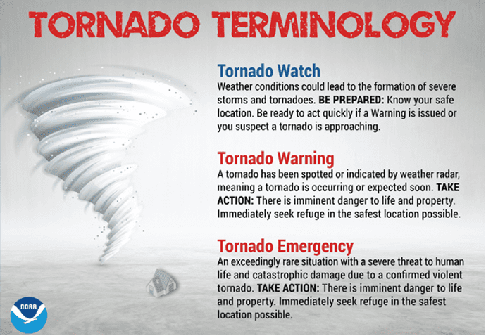
One essential preparedness measure is to sign up for emergency alerts and warnings in order to stay informed on local weather forecasts and follow instructions from emergency officials. During severe weather, it is important to know the differences between and pay attention to the NWS’s three key alerts:
- Tornado Watch – indicates that conditions are favorable for producing a tornado in or near the watch area (which may cover several counties or states), and alerts you to review your emergency plans and be ready to take action in the event of an emergency.
- Tornado Warning – issued by your local forecast office when a tornado has been sighted or determined by radar (typically within a city or small county), and is a signal to take shelter until the warning has expired.
- Tornado Emergency – the NWS’s highest alert issued when there is confirmation of a tornado touch down in the area, necessitating that everyone in the emergency immediately seek shelter in the safest location possible.
Understand Tornado Alerts: NOAA NWS
If you have been impacted by a tornado, it is important to monitor updated information from authorities before leaving your shelter. Additional safety measures include: stay clear of fallen power lines or broken utility lines; avoid entering damaged buildings until given official clearance; limit non-emergency phone calls to free up the network for emergency communications; and take precautions during debris cleanup by wearing long pants, thick-soled shoes, and gloves.
Disaster survivors should visit FEMA.gov for updated resources and information on current disaster declarations, including how to apply for federal assistance. Support services are available for individuals, families, governments, and private non-profits.