WEDNESDAY, JULY 7, 2021 AS OF 9:00 AM EST
According to the National Oceanic and Atmospheric Administration (NOAA) National Hurricane Center (NHC), Tropical Storm Elsa is 50 miles south-southwest of Cedar Key, Florida, moving almost parallel to the west coast of the state at 14 miles per hour (mph). Turbulent winds and heavy rains continue to move inland over the western Florida Peninsula. The NHC predicted Elsa will move close to or over parts of Florida’s west coast by late Wednesday morning or afternoon, before moving across the mid-Atlantic and southeastern United States (US) through Thursday.
Elsa is anticipated to produce three to six inches of rain across western and northern portions of the Florida Peninsula, with heavy rain also affecting southeast Georgia, the Lowcountry of South Carolina, coastal sections of North Carolina, and one to three inches across the Northeast and New England. There is also potential tornado risk across west-central to north Florida throughout Wednesday afternoon.
Yesterday, heavy rains and wind gusts in excess of tropical storm force affected portions of the Florida Keys – Key West recorded sustained winds of 43 mph, gusting to 59 mph; Sand Key, located just west of Key West, reported sustained winds of 53 mph, gusting to 63 mph. Additionally, several Weather Underground reports indicate portions of the Florida Keys accumulated 4 to 7 inches of rain between midnight and 12:30 p.m. EDT Tuesday, July 6.
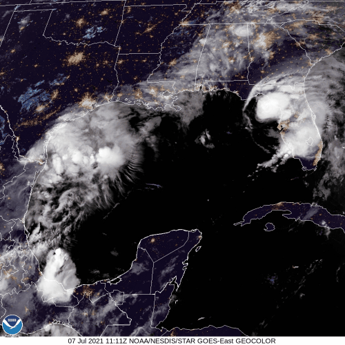
GOES-East – Sector view Gulf of Mexico – GeoColor: NOAA
Elsa is the first hurricane this season, and the fifth named storm for the Atlantic this year. After gaining strength as a Category 1 hurricane on Friday, Elsa was downgraded after making landfall in the Caribbean. Hurricane warnings remain in effect in 33 counties as Elsa gains speed before the projected touch down in Central Florida this morning. Governor DeSantis announced that Floridians should be mindful of local evacuation orders and take caution when setting up generators in case of a power outage during or immediately following the storm. In a press conference on Wednesday morning, Governor DeSantis stressed that residents should listen to local emergency managers and take photos of debris and damage to assist with FEMA recovery funding following the storm.
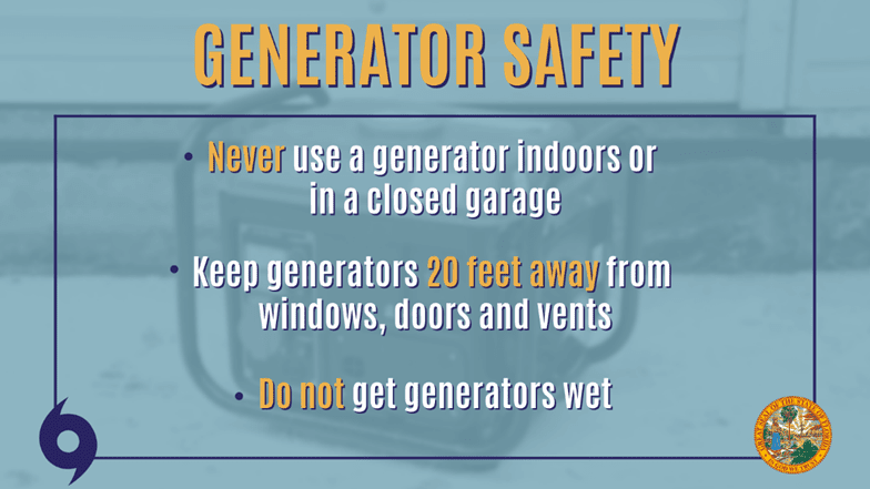
Generator Safety Tips: Office of Governor DeSantis
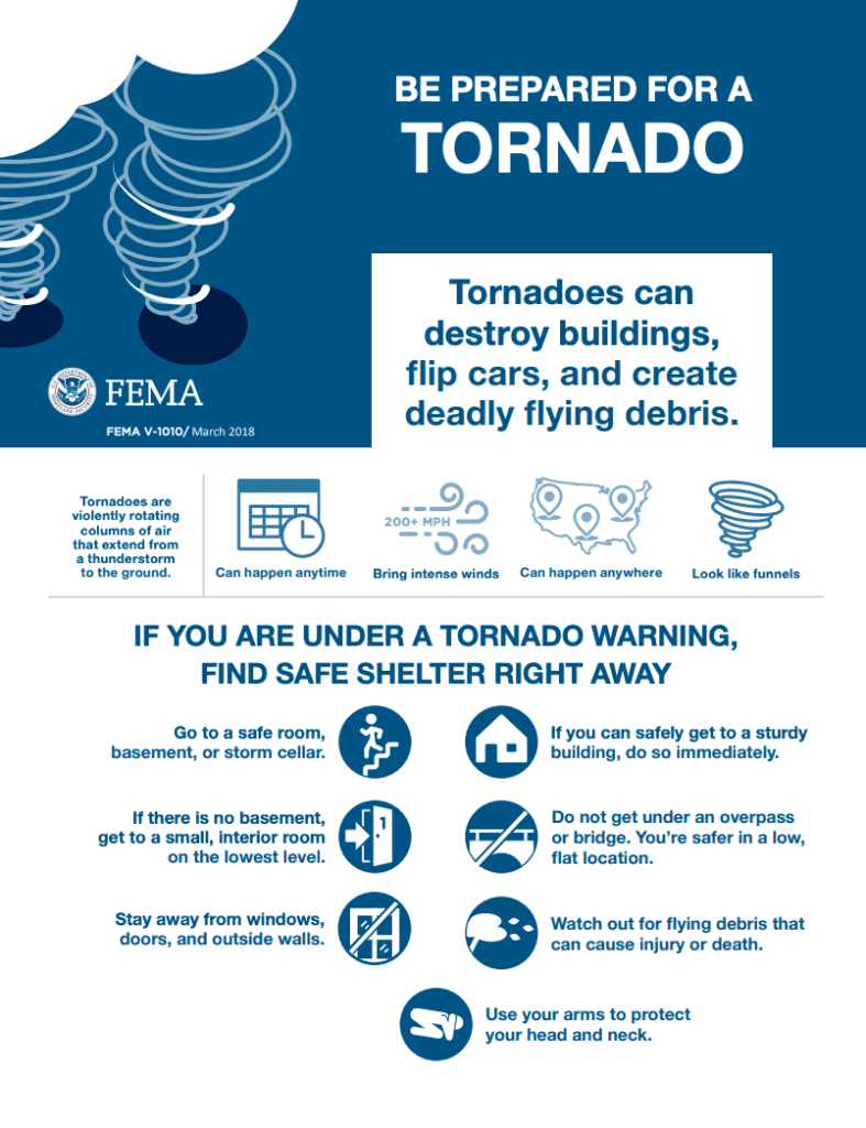
FEMA Guidance on Tornadoes: FEMA
As Elsa moves across central Florida, there is an increased chance of tornadoes. Additionally, as the storm moves inland, the NHC warns that there is an increased chance of tornadoes for southeast Georgia and eastern South Carolina. The Federal Emergency Management Agency (FEMA) encourages individuals to take the necessary precautions and prepare for tornadoes. Tornadoes can appear suddenly, destroy buildings, flip cars, and create deadly flying debris. FEMA suggests individuals under Tornado Warnings seek shelter right away. Additionally, FEMA encourages individuals to take the necessary precautions and prepare for flash flooding. Flash floods can develop with little to no warning, quickly changing the surrounding area. FEMA suggests individuals seek higher ground, avoid walking or driving in flood waters, and heed the warnings of local authorities. The Hagerty Blog Team will continue to provide information and updates.
PUBLIC ADVISORIES
Here’s the breakdown of public advisories from NOAA’s NHC:
TROPICAL STORM WARNING:
RELATED STORIES
Stay updated and learn more here:
- Remember, Ready.gov provides information on how to prepare for a storm and how to keep you and your family safe.
- Understanding the meaning of hurricane maps – a NY Times Opinion Piece: Those Hurricane Maps Don’t Mean What You Think They Mean