TUESDAY, SEPTEMBER 10, 2024, AS OF 12:30 PM EDT
According to the National Oceanic and Atmospheric Administration’s (NOAA) National Hurricane Center (NHC), as of 11:00 a.m. Eastern Daylight Time (EDT), a Tropical Storm Warning is in effect for several communities in Texas, Louisiana, and along the Mississippi/Alabama border due to Tropical Storm Francine. The NHC forecasts that Francine is likely to develop into a hurricane by the evening of Tuesday, September 10, and is expected to make landfall along the coast of Southwest Louisiana on Wednesday, September 11.
At 11:00 a.m. EDT, the NHC reported that Tropical Storm Francine was located in the Gulf of Mexico, about 120 miles Southeast of the mouth of the Rio Grande River, and 425 miles Southwest of Morgan City, Louisiana. The storm’s maximum sustained winds are near 65 miles per hour (mph) with tropical storm force winds extending outward up to 140 miles from the center.
In anticipation of Francine’s landfall, Storm Surge Warnings have been issued for portions of the Upper Texas, Louisiana, and Mississippi coastlines, as well as Hurricane Warnings for the Louisiana coast from Sabine Pass to Grand Isle, Louisiana. Additionally, mandatory evacuations are in place for portions of Louisiana, including low lying areas of Lafourche Parish, located south of New Orleans, and Cameron Parish, located west of Lafayette on the border of Texas. Mandatory evacuations have also been ordered for parts of Jefferson, Plaquemines, and Terrebonne Parishes, which are located outside of the levee system.

Tropical Storm Francine – GeoColor: NOAA
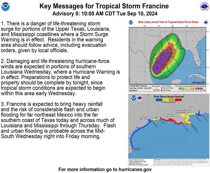
As of 11:00 a.m. EDT, the NHC reports that tropical storm conditions are expected to affect Mexico and South Texas through Tuesday afternoon, September 10. These conditions may extend along portions of the Texas coast Tuesday evening and into eastern Louisiana on Wednesday, September 11. In addition, Francine is anticipated to produce an average of four to eight inches of rainfall across large portions of Louisiana and Mississippi, with some regions potentially receiving upwards of 12 inches, through the morning of Friday, September 13. This heavy rainfall may result in flash and urban flooding.
Storm surge presents another major hazard, often the most dangerous aspect of tropical storms and hurricanes. The NHC reports that the deepest surge will occur along the immediate coast near and to the east of the landfall location, where it will be accompanied by large and dangerous waves. If peak surge occurs at the time of high tide, flood waters could reach five to 10 feet in Rockefeller Wildlife Refuge to Port Fourchon, Louisiana and Vermilion Bay, Louisiana. While the storm surge is not expected to compromise the main levee system, some local levees might experience overtopping.
In Mississippi, high winds from Francine have the potential to result in several downed and broken trees due to previous and ongoing drought conditions causing dry soil and brittle vegetation, which makes trees more susceptible to breakage. Entergy, the utility that provides electricity to large portions of Louisiana, Mississippi, and Alabama is preparing emergency crews to respond to restore power and monitoring the ongoing concern related to vegetative impacts to power lines and other equipment.
Key Messages for Tropical Storm Francine: NHC
To prepare for the forecasted impacts of Francine, Louisiana Governor Jeff Landry issued a state of emergency declaration on Monday, September 9, in order to equip communities statewide with the resources to help protect their life, safety, and welfare. life, safety, and welfare.
As communities begin preparedness activities, Hagerty’s Deputy Director of Response, Nicole Morales, shares insights; “As my fellow Louisianians know, Mother Nature rarely abides by forecasts or planned trajectories. Those living within Francine’s “cone of concern” should take advantage of the time remaining to fortify their property; enable ease of evacuation, if needed (e.g., fill gas tank, refill medications, prepare pets); and help neighbors and loved ones with limited mobility and/or means (e.g., no personal transportation) identify supportive services and resources to mitigate risk (e.g., government-assisted evacuation and sheltering).” Ongoing preparedness activities include City-operated sandbagging stations, which have opened in several coastal cities.
Here are some tips to help prepare for potential impacts from Tropical Storm Francine. pic.twitter.com/swY79f1cJi
— NWS Jackson MS (@NWSJacksonMS) September 9, 2024
X: NWS Jackson Mississippi (MS)
Ahead of the storm, Hagerty’s Director of Response, Lee Mayfield, advises, “As Tropical Storm Francine continues to develop in the Gulf of Mexico, residents in its path should take time now to prepare for potential impacts, including talking through their family emergency plan. With a short window from storm formation to landfall, it’s even more important to pay close attention to state and local officials and the direction they provide.”
Tropical Storm Francine brings potential life-threatening storm surge to many coastal communities. NOAA provides information on storm surge warnings and storm surge watches to help individuals be better prepared for potential hazardous situations. The Federal Emergency Management Agency (FEMA) provides guidance to individuals preparing for, experiencing, or affected by hurricanes. Additionally, FEMA encourages individuals to take the necessary precautions and prepare for flash flooding. Flash floods can develop with little to no warning, quickly changing the surrounding area. FEMA suggests individuals seek higher ground, avoid walking or driving in flood waters, and heed the warnings of local authorities. Over the coming days and weeks, Hagerty’s Blog Team will continue to provide guidance on making effective preparations for long-term recovery, as well as continuing our situational updates.
Stay Updated and Learn More Here:
- Remember, Ready.gov provides information on how to prepare for a storm and how to keep you and your family safe.