Thursday, May 25, as of 1:00 pm (EDT)
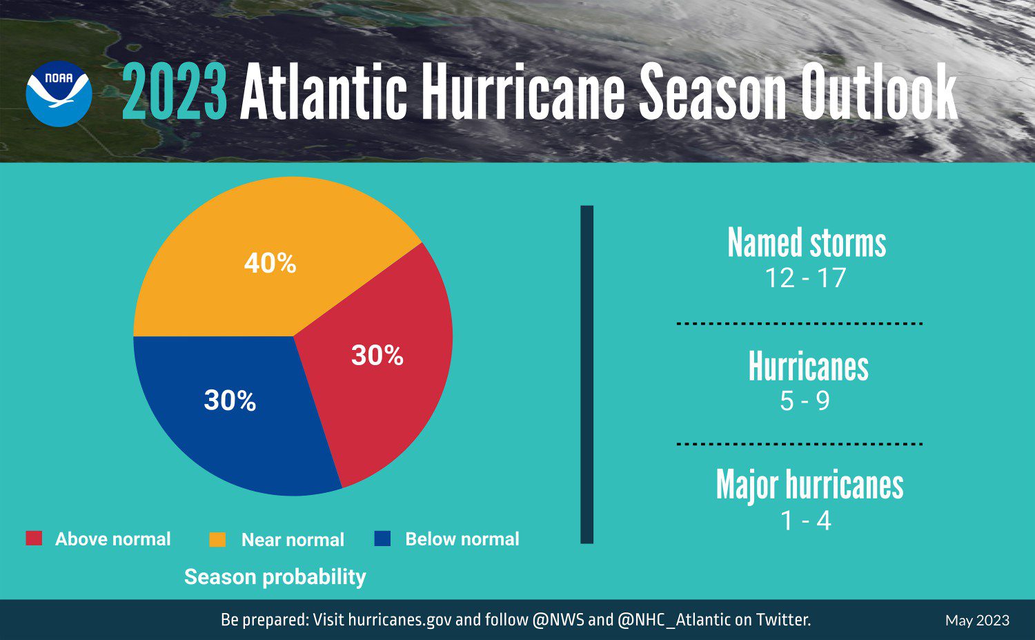
On Thursday, the National Oceanic and Atmospheric Administration (NOAA) released its 2023 Atlantic Hurricane Season Outlook. Forecasting a near-normal season, NOAA estimates 12 to 17 named storms, five to nine hurricanes, and one to four major hurricanes to develop in the Atlantic basin this season. This is a near-normal forecast for the regular season average of 14 named storms, seven hurricanes, and three major hurricanes. Although the historical peak of hurricane season is still a few months away, recent years have shown more early storm formations, something forecasters and emergency managers will be on the lookout for in the coming weeks. This year, NOAA has implemented various upgrades and improvements to its hurricane forecast models, expanding the capacity of its operating system by 20 percent and extending its lead time for tropical cyclone forecasts from five to seven days. According to United States (US) Deputy Secretary of Commerce Don Graves, these advancements have improved forecast track accuracy by 40 percent since 2017.
Atlantic Hurricane Season Outlook
The 2023 Atlantic hurricane season begins on June 1 and lasts until November 30. Today, the NOAA Climate Prediction Center (CPC) forecast a 40 percent chance of a near-normal hurricane season in the Atlantic, with a 30 percent chance for an above-normal and a 30 percent chance for a below-normal season. There are 12 to 17 named storms anticipated for the season, with winds reaching 39 miles per hour (mph) or higher. Five to nine of these storms could likely become hurricanes, with one to four predicted to become major hurricanes as either Category (Cat) 3, Cat 4, or Cat 5. These storms can reach wind speeds of 111 mph or higher, and NOAA provided the storm range with a confidence rate of 70 percent.
These predictions support the CPC’s forecast for a return to a “potentially significant” El Niño, or climate pattern marked by warmer-than-normal surface waters in the Pacific Ocean. While an El Niño episode is historically known to suppress tropical cyclone and hurricane formation in the Atlantic basin, its warm water can fuel increased activity in the central/eastern Pacific Ocean. According to the CPC’s report issued on May 11, El Niño is likely to form sometime during June or July and persist into the winter – when its impacts are felt strongest.
NOAA: 2023 Atlantic Hurricane Season Outlook
Pacific Hurricane Season Outlook
NOAA’s CPC additionally provided a 2023 hurricane season outlook for the Eastern Pacific Ocean, indicating a 55 percent chance for above-normal tropical cyclone activity throughout the season. The forecast further noted a 35 percent chance for near-normal activity, with a 10 percent chance for an above-normal season. Forecasters anticipate between 14 to 20 named storms, seven to 11 hurricanes, and four to eight major hurricanes will affect the Eastern Pacific hurricane region from May 15 through November 30, with a confidence rate of 70 percent. For the Central Pacific region, NOAA’s outlook indicates a 50 percent chance for above-normal activity, predicting four to seven tropical cyclones will affect the Central Pacific hurricane region, which includes tropical depressions, named storms, and hurricanes.
Recently, forecasters, emergency managers, vendors, and volunteers met in West Palm Beach, Florida, for the 2023 National Hurricane Conference to discuss best practices and innovative approaches to moving our profession forward. Participation at the conference this year underscored that both seasoned and new emergency managers alike are preparing seriously for another active season this year.
At NOAA’s Season Outlook Press Conference, Federal Emergency Management Agency (FEMA) Administrator Deanne Criswell said, “As we saw with Hurricane Ian, it only takes one hurricane to cause widespread devastation and upend lives.” Regardless of the number of predicted named storms this season, it is important that you know your risk, be prepared, and follow emergency guidance from state and local officials. Here are some important tips Hagerty’s Director of Response Programs, Lee Mayfield, encourages emergency managers and decision-makers to keep in mind as they prepare for the next six months.
Important Tips for Emergency Managers
1. Have a plan in place to manage and support those coming to support you. Amidst a disaster response, there is often an extensive network of mutual aid to support state and local jurisdictions in the response. This ranges from neighboring cities and counties to emergency management professionals and first responders from across the country. Mechanisms like the Emergency Management Assistance Compact (EMAC) are in place to allow rapid deployment of personnel through pre-established agreements. Local emergency managers should recognize the value that mutual aid networks can bring to a response mission and be prepared to integrate mutual aid personnel and resources into the response operation. While many will come self-sufficient, with the goal of not overburdening the impact area, identifying workspace in the Emergency Operations Center (EOC) or other facilities and including outside responders in feeding and support plans are advised. If planned for ahead of time, these mutual aid partners can add value to a complex response and lighten the load on the local team.
2. Do not focus on the skinny black line. The 2022 hurricane season brought additional attention to the National Hurricane Center’s (NHC) forecast cone of uncertainty. Hurricane Ian’s impacts extended far beyond the cone, and we should continue to educate the public that dangers always exist outside of it. While this is not a new challenge, it is one that remains difficult to communicate to our stakeholders and residents. The cone represents the probable track of the center of a tropical cyclone and incorporates historical forecast errors in determining this area. Emergency managers should continue to work with their National Weather Service (NWS) and communications partners to highlight risks that still exist to individuals and communities outside of the cone.
3. Confirm all pre-event contracts. In addition to mutual aid deployments, our EOCs normally scale to include representatives from the private sector in support of response operations. This could include debris haulers and monitors, cost-recovery subject matter experts, feeding vendors, and other EOC staff augmentation. If these contracts have not been activated in a while, they may be easy to overlook during pre-hurricane season planning. Taking the time to review all pre-event contracts and confirm readiness for if and/or when they need to be activated. Emergency managers should have these partners on speed dial and having them in the EOC before landfall is a best practice. Setting up an early season meeting(s) with key vendors to review protocols, deployment timelines, and scope of work will allow roles and responsibilities to be defined and take some of the guesswork out of your vendor activation plan.
4. Take care of our teams. When responding to a large-scale event like a hurricane, long days and hours are expected. It can often be weeks to months until the operation balances out, and there is an opportunity for real rest. As emergency managers, we spend our careers planning how to best respond to these events, and we see it as our obligation to see it through. At the same time, as leaders, we should recognize that while our teams are passionate about what they do, they will need support throughout an extended response operation. This could include maximizing the use of mutual aid EOC support teams or staff augmentation, an intentional scheduling effort to ensure days off and rotations, and ways to reduce stress across the operation. Thinking about ways to support our teams now will make sure it remains a priority when an EOC activation is underway.
Conclusion
This hurricane season, there is an increase in uncertainty for officials as a result of two contradictory factors: the developing El Niño and an unusually warm Atlantic Basin. Veteran and new emergency managers alike will once again be required to use their expertise, networks, and partnerships to overcome these challenges. Through strategic coordination, emergency managers can build trust with constituents and exemplify the value of the protective measures they are asking them to take.
NOAA: Prepare Before Hurricane Season
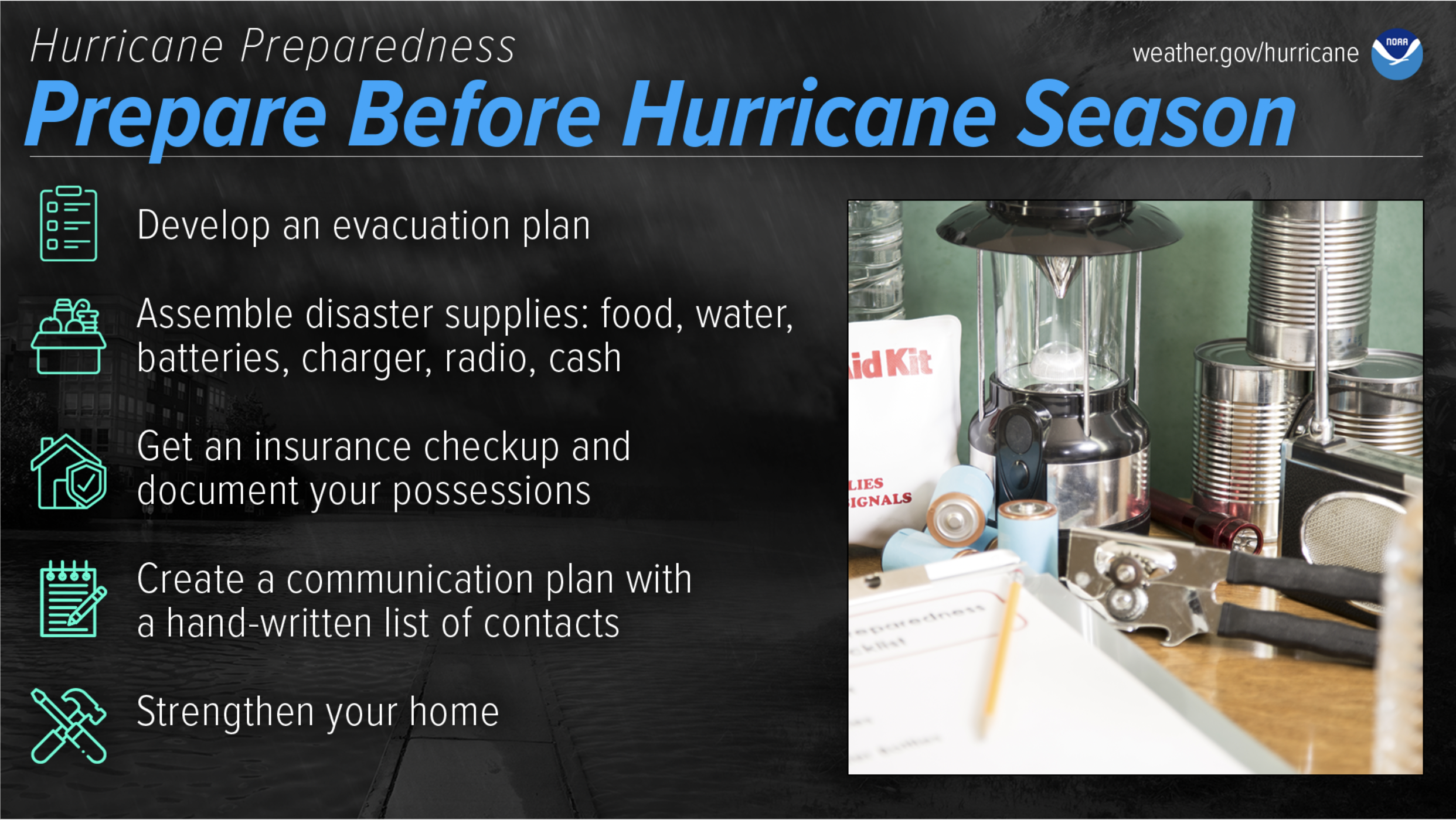
FEMA encourages individuals to prepare before a tropical storm or hurricane warning is in effect. The impacts of a storm can be felt hundreds of miles inland in the form of wind and water hazards. Be sure to understand the potential hazards that may affect your community. After determining the risks of severe weather that have the possibility of impacting your community, it is critical to then:
- Create a plan among your family and household in the event of a storm;
- Sign up for severe weather alerts to receive timely and reliable guidance in the event of an emergency(s);
- Be prepared to shelter in your home, workplace, or outside location when instructed by local officials;
- Plan your evacuation routes and where you will shelter if local officials advise evacuation;
- Collaborate with your family and household to establish a communication plan in the event of an emergency; and
- Keep your emergency preparedness kit stocked and ready to go.
Emergency plans should be personalized based on the unique composition of your family and household – considering the needs of young children, older adults, and pets; dietary and medical requirements; and individuals living with disabilities. Additional preparedness opportunities could include completing FEMA’s Family Emergency Communication Plan or using this resource as a guide for documenting important contact information that can be shared with your family and household for safekeeping. Once your plan is set, periodically review and rehearse the plan so that everyone involved can become familiar with their responsibilities and equipped with the confidence to make quick decisions during a real emergency. FEMA suggests several precautionary steps you can take to protect your home and personal property from damage by high winds and floods, including reviewing your flood insurance coverage.
Related Stories
Throughout the hurricane season, Hagerty will continue to provide guidance on making effective preparations for long-term recovery, as well as continuing our situational extreme weather event updates.
Stay Updated and Learn More
- Remember, Ready.gov provides information on how to prepare for a storm and how to keep you and your family safe.

Keep track of Hagerty’s incident coverage here:
2023 Hurricane Season