WEDNESDAY, SEPTEMBER 28, 2020 AS OF 9:00 AM EST
According to the National Oceanic and Atmospheric Administration (NOAA) National Hurricane Center (NHC), Hurricane Ian, a now Category (Cat) 4 hurricane, is rapidly intensifying, with the center’s location projected about 55 miles from the coast of Florida. Ian is moving north-northeast at approximately 10 miles per hour (mph), with maximum sustained winds of 155 mph, as of 8:00 a.m. Eastern Daylight Time (EDT). Ian is expected to strengthen throughout the day and is projected to make landfall as a major Cat 4 hurricane, with Hurricane-force winds currently reaching outward up to 40 miles and tropical storm force winds reaching 175 miles from the center of the storm. The eye of Hurricane Ian is currently 40 miles wide.
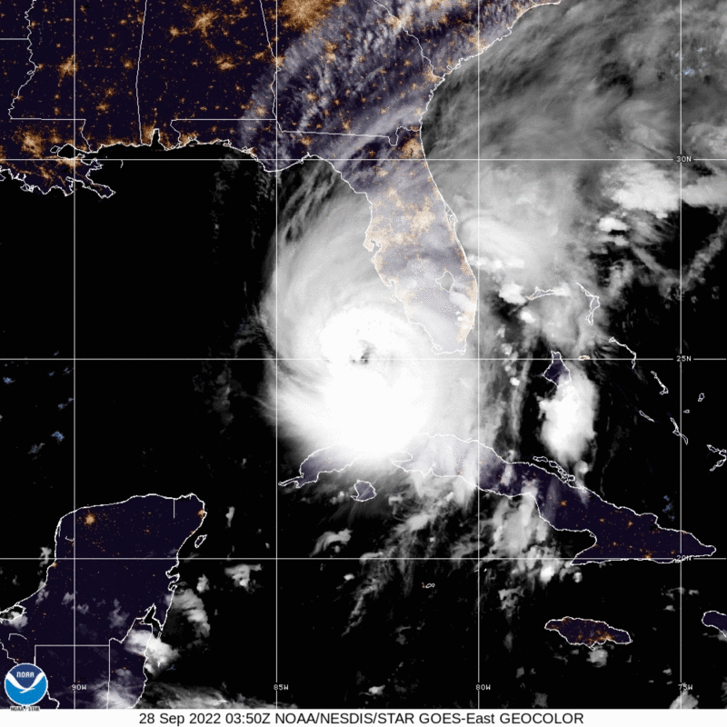
Hurricane Ian- GeoColor: NOAA
The NHC warns that Ian will bring catastrophic flash flooding and surge-related flooding to areas around the West Coast of Florida, with storm surge forecasted to be between one and 16 feet. Heavy rainfall is also projected to impact areas across Florida with the potential to bring up to 24 inches of rain in parts of Central Florida. Additionally, Central Florida is at risk for “widespread, life-threatening catastrophic flash, urban, and river flooding.
9/28 7am EDT UPDATE: Catastrophic storm surge along with destructive waves from #Ian are expected along the southwest Florida coastline from Englewood to Bonita Beach, including Charlotte Harbor. Residents should urgently follow evacuation orders from local officials. pic.twitter.com/EQ535FGmhY
— NHC Storm Surge (@NHC_Surge) September 28, 2022
Twitter: NHC Storm Surge
As Hurricane Ian draws closer to making landfall on Florida at its highest strength thus far, state officials estimate that more than 2.5 million people have been issued evacuation orders, including mandatory orders across 10 counties. As of Wednesday morning,September 28, nearly 90,000 Florida residents have reported power outages throughout the state. Storm-force winds have already begun to impact parts of Southern Florida, with at least two confirmed tornadoes reported in Broward County, where North Perry Airport saw extensive damage to its planes and hangars. Due to the projected path of the storm, all of the state’s major theme parks and centrally located schools and stores have announced closures.
Earlier this morning, Florida Governor Ron DeSantis held a briefing warning Floridians of the storm’s potential “major impacts in terms of wind, rain, and flooding” once it makes landfall on Florida’s west coast. The NWS currently has storm surge warnings in effect for six areas along Florida’s west coast. In continuation of its preparation efforts, the Florida Division of Emergency Management (FDEM) is mobilizing and coordinating resources, including the supply and deployment of 85 truckloads of water and 75 loads of ready to eat meals (MREs). At the direction of state officials, an Incident Management Team (IMT) from Ohio is also en route to provide additional response and recovery support after the storm.
In addition, Georgia Governor Brian Kemp issued a state of emergency declaration for the State on Tuesday, September 27, in anticipation of the storm, as Hurricane Ian is expected to begin impacting the state on Friday. The order will go into effect Thursday afternoon, September 29.
Hurricane Warnings are in effect for much of the West Coast of FL. Many areas are starting to experience severe weather, including tornadoes.
Residents are encouraged to have multiple ways to receive weather alerts overnight & heed all warnings from local officials. pic.twitter.com/eBdndhoP6v
— FL Division of Emergency Management (@FLSERT) September 28, 2022
Twitter: FL Division of Emergency Management
Individuals at risk are encouraged to secure their homes, remain up-to-date with information from their local NWS office and local government/ emergency management office, and follow guidance issued by local officials. The Federal Emergency Management Agency (FEMA) provides guidance to individuals preparing for, experiencing, or being affected by hurricanes. Hurricane Ian brings the potential for life-threatening storm surges to many coastal communities. Individuals should heed the warnings of local authorities and prepare for hurricane and severe weather conditions. It’s important to remember that flash floods can develop with little to no warning. It is imperative that individuals seek higher ground and avoid walking or driving in flood waters. Additionally, FEMA encourages individuals to take the necessary precautions and prepare for flash flooding. The Hagerty Blog Team will continue providing information and updates.
STAY UPDATED AND LEARN MORE HERE:
- Remember, Ready.gov provides information on how to prepare for a storm and how to keep you and your family safe.
- Understanding the meaning of hurricane maps – a NY Times Opinion Piece: Those Hurricane Maps Don’t Mean What You Think They Mean