THURSDAY, SEPTEMBER, 2022, AS OF 9:00 AM EDT
According to the National Oceanic and Atmospheric Administration (NOAA) National Hurricane Center (NHC), Hurricane Ian is now a Tropical Storm with maximum sustained winds of 65 miles per hour (mph). As of 8:00 a.m. Eastern Daylight Time (EDT), Tropical Storm Ian was nearing Cape Canaveral as it moved northeast at 8 mph. Tropical Storm force winds currently are reaching outward up to 415 miles from the center of the storm. Hurricane Ian made landfall around 3:00 p.m. near Cayo Costa as a Category 4 Hurricane, with winds as high as 150 mph, tying for the fifth strongest hurricane to hit the United States (US) in recorded history.

Hurricane Ian- GeoColor: NOAA
As of 9:00 a.m. EDT, more than two million Florida customers were without power, and communications remain unreliable due to downed cell phone towers. Hurricane Ian broke records for rainfall in Orlando, as well as for storm surges in Naples and Fort Myers, leaving communities flooded and with extensive damage. According to Governor Ron DeSantis, the storm surge peaked at approximately 12 feet in some coastal areas of the state. Water inundated homes on Florida’s West Coast homes while winds downed power lines and trees, tearing roofs and siding off homes. The hurricane’s strong winds prevented first responders from carrying out rescue operations on Wednesday, so the full breadth of damage and casualties is still unknown. Additionally, an unknown number of people are still stranded in flooded areas after choosing not to evacuate, according to Governor DeSantis.
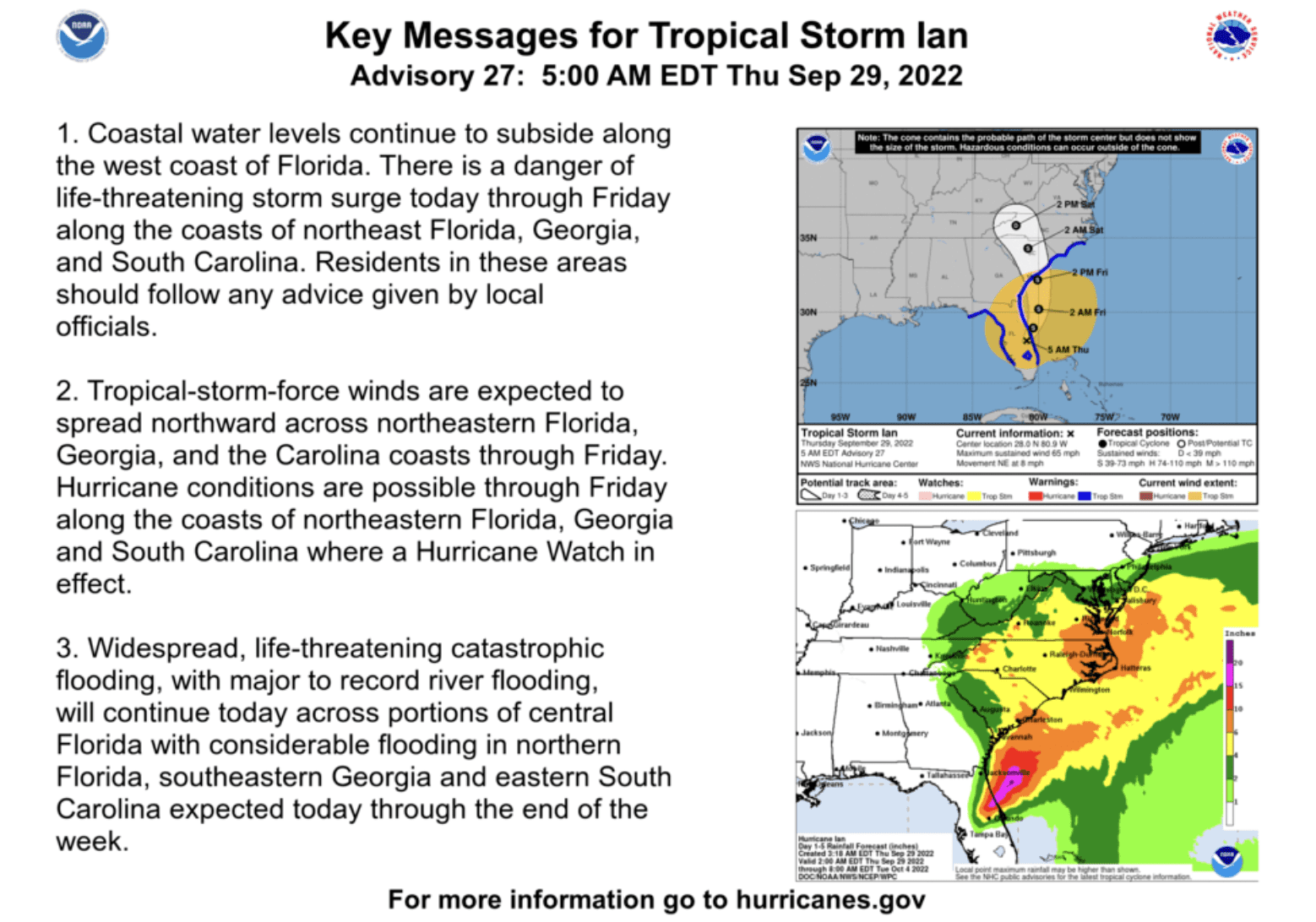
NHC: Key Messages
On Thursday, September 29, President Biden approved a major disaster for Florida, ordering federal funding be made available to the counties of Charlotte, Collier, DeSoto, Hardee, Hillsborough, Lee, Manatee, Pinellas, and Sarasota. In addition, the Federal Emergency Management Agency (FEMA) Administrator Deanne Criswell, announced that Thomas J. McCool will be the Federal Coordinating Officer for recovery operations across impacted areas.
With Tropical Storm Ian now making its way across the state, areas of northeastern Florida will face risks of severe flash flooding and storm-force winds Thursday morning. According to the NHC, Ian is projected to exit Florida’s northeastern Atlantic coast late Thursday night, September 29, where it will further weaken before heading north and potentially reaching “near hurricane strength” again when making its third landfall into South Carolina Friday afternoon. Tropical storm warnings have been issued for the coasts of Florida, Georgia, South Carolina, and North Carolina, along with a hurricane watch extending from Florida’s northeast coast to the coast of Charleston County, South Carolina.
On Tuesday, September 27, Georgia Governor Brian Kemp declared a State of Emergency for all counties across the state in preparation for Ian’s impact. In addition, Governor Henry McMaster issued a State of Emergency declaration for South Carolina on Wednesday, September 28, activating the state’s emergency operations plan and enabling preparation efforts across the state.
Floridians should take precautions to keep themselves & their families safe as #HurricaneIan makes its way through Florida:
⚠️ Don’t go outside until the storm has passed
⚠️ Stay away from downed power lines
⚠️ Never walk or drive through flooded watershttps://t.co/S49ep6jUOA pic.twitter.com/zIEZkYA8C3— FL Division of Emergency Management (@FLSERT) September 28, 2022
Twitter: FL Division of Emergency Management
FEMA encourages individuals to take the necessary precautions and prepare for flash flooding. It’s imperative to remember that flash floods can develop with little to no warning, quickly changing the surrounding area. FEMA suggests individuals seek higher ground, avoid walking or driving in flood waters, and heed the warnings of local authorities. Additionally, the NWS offers advice and guidance for those about to experience, currently impacted by, or previously affected by tropical storms and hurricanes. Individuals at risk are encouraged to secure their homes, remain up-to-date with information from their local NWS office and local government/emergency management office, and follow guidance issued by local officials.
During a power outage, FEMA encourages individuals to keep refrigeration sources closed, disconnect appliances to avoid damage from electrical surges, and keep up to date on heating, cooling, and other sheltering locations offered in the community. Power outages introduce many risks to a community’s safety and well-being, including disrupting access to communications, transportation, and other essential services.
Additionally, in the midst of and in the aftermath of a disaster, access to drinking water may be limited or cut off. Under these circumstances, it is important to reduce activity levels and stay cool as best as possible in order to limit water intake while consuming the amount of water your body needs; to avoid drinking contaminated water for as long as possible, and to limit the consumption of carbonated and caffeinated beverages which may lead to increased dehydration. Upon the guidance of local emergency officials, it may be necessary to treat water to ensure it is safe to use for drinking, food preparation, or other household needs.
The Hagerty Blog Team will continue providing information and updates.
STAY UPDATED AND LEARN MORE HERE:
- Remember, Ready.gov provides information on how to prepare for a storm and how to keep you and your family safe.
- Understanding the meaning of hurricane maps – a NY Times Opinion Piece: Those Hurricane Maps Don’t Mean What You Think They Mean