TUESDAY, SEPTEMBER 15, 2020 AS OF 1:30 PM EDT
The National Oceanic and Atmospheric Administration’s (NOAA) National Hurricane Center (NHC) reported Hurricane Sally is 55 miles south of the mouth of the Mississippi River, moving northwestward at 2 miles per hour (mph). Sally is currently a Category 1 hurricane with maximum sustained winds of 85 mph. According to the NHC, Sally is expected to produce “historic” flooding with “extreme life-threatening flash flooding” along the northern Gulf Coast throughout Wednesday. Hurricane Sally is expected to bring intense rainfall, and the hurricane is forecast to create 10 to 20 inches of rain (with isolated amounts of 30 inches) inland of the central Gulf Coast. The storm surge from Sally could reach heights as great as 6 to 9 feet in parts of Mississippi and the southwest Alabama coast.
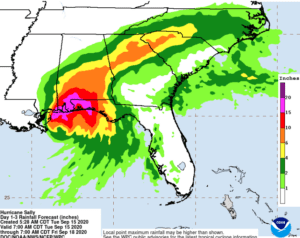
Hurricane Sally Rainfall Projections: NOAA NHC
The NHC cautioned the greatest potential for surge overflow is expected to occur along the Alabama coast, including Mobile Bay. A Hurricane Warning is in effect for the area between Bay St. Louis, Mississippi and Navarre, Florida. From Tuesday to Wednesday, there is a risk of isolated tornadoes across parts of the Florida Panhandle and southern Alabama. The hurricane is projected to move further inland on Wednesday, moving southwest and bringing 4 to 8 inches of rainfall across parts of southeastern Mississippi, southern and central Alabama, northern Georgia, and the western Carolinas.
Mississippi Governor Tate Reeves wrote on Twitter that the hurricane is “the real deal,” and urged residents to evacuate from low-lying areas. Federal emergencies have been declared in Louisiana, Alabama, and Mississippi.
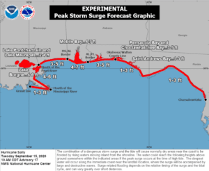
Hurricane Sally Peak Storm Surge Forecast: NOAA NHC

UnSplash: Joanne Francis
Meanwhile, according to the National Interagency Fire Center, wildfires have claimed over 4,600,600 acres in the last 14 days, wreaking havoc for communities across 12 western states. As of September 15, 2020, the death toll has reached 27 people across Washington, Oregon, and California, according to ABC News. Residents nearest to 39 active, large wildfires along the West Coast and in Colorado remain ready to evacuate. An estimated 40,000 residents in Oregon were evacuated and 500,000 were under evacuation orders by the State of Oregon’s Press Release on September 11th. Most states in the western half of the United States (US) have at least one active wildfire burning across the state, and some states, like California, have over 20 active fires burning.
Seattle, WA, Portland, OR, and Los Angeles, CA, are the three largest cities in each West Coast state, and have unhealthy to hazardous air quality according to AirNow.gov. Portland’s air quality is so hazardous that residents are being urged to stay inside and cease outdoor activity or exercise. Oregon and California are also each experiencing between 10,000 – 50,000 power outages.

NOAA Guidance Flood Safety: Source
The Federal Emergency Management Agency (FEMA) provides guidance to individuals preparing for, experiencing, or affected by hurricanes. Hurricane Sally brings potential for life-threatening storm surge to many coastal communities. Individuals should heed the warnings of local authorities and prepare for hurricane and severe weather conditions.
PUBLIC ADVISORIES
To get a breakdown by State and County of public advisories from NOAA’s NWS in decreasing order of severity, click here.
RELATED STORIES
- Remember, Ready.gov provides information on how to prepare for Wildfire and how to keep you and your family safe.
- The Los Angeles Times regularly updated tracking of California Wildfires: California Wildfires Map.
- The National Fire Protection Association provides wildfire preparedness tips: link
- Marin County provides a wildfire evacuation checklist: link
- FEMA provides an information video about how to be prepared for Wildfires: link
- Understanding the meaning of hurricane maps – a NY Times Opinion Piece: Those Hurricane Maps Don’t Mean What You Think They Mean