The 2022 Atlantic hurricane season officially ended on November 30, 2022, after producing 14 named storms, according to the National Oceanic and Atmospheric Administration (NOAA). Storms are named when they reach wind speeds of 39 miles per hour (mph) or greater and become hurricanes when their wind speeds reach 74 mph. This year, the Atlantic basin saw a total of eight hurricanes in 2022.
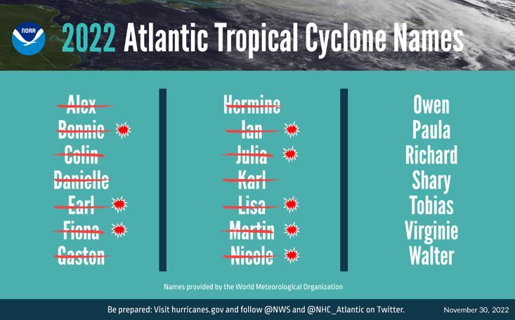
The 14 named storms and 8 named hurricanes of 2022: NOAA
Two hurricanes this year, Fiona and Ian, became major hurricanes when they surpassed 111 mph. Hurricane Nicole, which made landfall as a Category (Cat) 1 hurricane in Florida on Thursday, November 10, was considered unusual by experts because it arrived so late in the season.
2022 Hurricanes
In May, NOAA’s Climate Prediction Center (CPC), part of the National Weather Service (NWS), predicted that the Atlantic would see an above-average hurricane season, making 2022 the seventh year in a row to receive the label. Then, on May 24, NOAA stated that they anticipated between 14 and 21 named storms, six to 10 hurricanes, and three to six major hurricanes through the 2022 season. On August 4, NOAA released an updated assessment of the season, with Federal Emergency Management Agency (FEMA) Administrator Deanne Criswell noting that “although it has been a relatively slow start to hurricane season… [we] cannot afford to let our guard down.” Residents of hurricane-prone areas were advised to stay vigilant and be ready when called upon to evacuate in the event of dangerous winds and storm surge.
The slow start to the 2022 Atlantic hurricane season gave way in September when two major hurricanes hit the United States (US): Fiona, which made landfall on Wednesday, September 18 in Puerto Rico as a Cat 1 and grew to a Cat 4 headed for Canada, striking Nova Scotia with 105 mph winds on September 24; and Ian, which hit the Gulf Coast of Florida on September 28 as a Cat 4, passing through Florida and making a second landfall in South Carolina as a Cat 1 hurricane on Friday, September 30. Lee Mayfield, Hagerty’s Director of Response, echoes Administrator Criswell, saying, “The 2022 Hurricane Season started off slow, and I think everyone was hoping for below-average hurricane activity as we entered September. Ian’s landfall late that month confirmed that just one storm can make it a memorable season. The catastrophic coastal damage from Ian will make the 2022 season go down in history.”
Hurricane Ian
On Wednesday, September 28, 2022, just after 3:00 p.m. EST, Hurricane Ian made landfall near southwestern Florida’s barrier island of Cayo Costa as a Cat 4 hurricane with winds reaching 150 mph, tying Hurricane Ida in 2021 for the fifth strongest hurricane to hit the US in recorded history.
Hurricane Ian hit the State of Florida after first strengthening from a tropical storm to a hurricane in the central Caribbean on Tuesday, September 26. It made landfall in Cuba the same day, with high winds and severe storm surge that knocked out the island’s power grid. After crossing over Florida, Hurricane Ian re-entered the Atlantic Ocean as a tropical storm, then strengthened to a Cat 1 Hurricane and made its second US landfall near Georgetown, South Carolina, on Friday, September 30. Storm winds reached 85 mph and caused widespread flooding and damage to coastal regions, including storm surges reaching up to seven feet in some areas, power outages, and infrastructure damage to North Myrtle Beach and Pawleys Island piers.
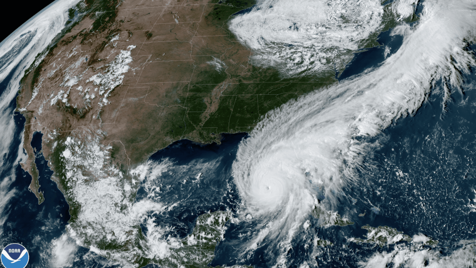
Hurricane Ian hovering over Florida and the Caribbean, September 27: NOAA
According to NOAA, Hurricane Ian’s rainfall was a 1-in-1,000-year event for the most impacted areas of Florida. Rain totals reached 15 inches over a 12-hour span in Placida, Florida, just north of Cayo Costa. Lake Wales, Florida, located in central Florida east of Tampa, reportedly received almost 17 inches of rain over a 24-hour period. Additionally, the cities of Winter Park, North Port, and Myakka City experienced 1,000-year flood events based on an estimated 12, 14, and 14 inches of rainfall in 12 hours, respectively.
Areas just south of the eye of the storm, including Fort Myers and Naples, were impacted by record-breaking storm surge, rising water levels, and fast-moving flood waters that can pose the greatest threat to life and property during hurricane events. Preliminary data from flood sensors show that 60 miles of Florida’s southwestern coastline saw a storm surge between one and two stories high. With eyes on the scene, Hagerty’s Lee Mayfield noted, “The surge experienced on Fort Myers Beach, Pine Island, and Sanibel showed how destructive and dangerous storm surge can be. We should continue to educate the public on how real a threat this can be, especially in areas that haven’t experienced it before.”
As a result of Hurricane Ian, more than four million customers across the state of Florida experienced power outages, including hundreds of thousands for many days after the hurricane passed. At a Thursday, September 29 briefing, Governor Ron DeDantis announced that emergency response crews had rescued more than 700 people to safety. According to Lee Mayfield, mobilizing mutual aid can be critically important to the success of response operations.
“From a disaster response perspective, emergency managers supporting each other via mutual aid systems is a key driver of success. In Southwest Florida, professional emergency managers from Florida and across the country deployed to the area and were embedded in local Emergency Operations Centers for over a month. This support system is crucial, and Florida’s jurisdictions are recovering faster because of these partnerships.”
The impacts of Hurricane Ian are significant. Ian currently ranks as the eighth-costliest US hurricane event since 1980, with over $50 billion in damages, and is the fifth-deadliest US hurricane event since 1963, responsible for 145 direct and indirect fatalities (preliminary toll).
The US Small Business Administration (SBA) has issued $1.2 billion in disaster loans throughout Florida, and the National Flood Insurance Program (NFIP) has distributed $919 million in claims. In addition, on Monday, November 28, Governor DeSantis announced the launch of Florida’s first-ever state-led sheltering and housing program, providing temporary sheltering options and housing repair assistance to those in need.
As of Monday, December 5, FEMA has issued more than $3.31 billion in federal grants, loans, and insurance payments to Florida, including $792 million to individual households impacted by the storm and nearly $400 million to the State of Florida’s emergency response efforts.
Hagerty’s Lee Mayfield is hopeful that these funding streams will bring a coordinated approach to lasting resilience in Southwest Florida. In his eyes, “Long-term recovery is complex and will take time, but there will be an opportunity for significant investment in communities at all levels. Just like we collaborate and work together during the response phase, these partnerships will be equally as important in recovery.”
As important as it is for individuals to stay vigilant and be ready to take action to evacuate, emergency managers and response agencies are key to the success of response and recovery activities in times of crisis. Mayfield notes that “Disaster response and recovery is a team sport. No one team or agency can be successful alone. It requires collaboration and partnerships at so many levels, and that was exemplified by the large number of responders who served and continue to remain focused on recovery across Florida.”
These events serve as opportunities to learn and develop future plans and best practices. Community investments in long-term recovery, including preparedness planning for future storm events, are going to be essential for moving forward and ensuring that communities are able to respond and recover as effectively as possible.
- Remember, Ready.gov provides information on how to prepare for a storm and how to keep you and your family safe.
- Understanding the meaning of hurricane maps – a NY Times Opinion Piece: Those Hurricane Maps Don’t Mean What You Think They Mean