TUESDAY AUGUST 31, 2021 AS OF 10:00 AM EST
Tropical Depression Ida is currently over northern Mississippi about 145 miles north-northeast of Jackson, Mississippi and about 185 miles southwest of Nashville, Tennessee and is moving northeast at around 12 miles per hour (mph) according to the National Oceanic and Atmospheric Administration (NOAA) National Hurricane Center (NHC). The classification for Ida was changed from a tropical storm to a tropical depression around 5:00 p.m. EDT on Monday. Maximum sustained wind speeds continue to be around 30 mph with higher gusts, but the NHC does not predict much change in strength over the next 48 hours.

Tropical Depression Ida – GeoColor: NOAA
Flood and flash flood watches continue throughout the Gulf Coast Region and extend across the Tennessee and Ohio Valleys, central and southern Appalachians, and into the Mid-Atlantic and southern New England. According to the National Weather Service (NWS), rainfall from 1 to 6 inches will affect these areas over the next few days, with the most (3 to 6 inches) potentially affecting the middle Tennessee Valley, Ohio Valley, central and southern Appalachians. People in these areas should continue to monitor the situation, listen to local authorities, and look for additional advisories from the NWS. Considerable flash flooding is also possible for these areas as well as the Mid-Atlantic and southern New England. Rivers are predicted to remain elevated into next week with possible isolated major riverine flooding forecasted for the Lower Mississippi Valley, western Alabama, Allegheny Mountains, and Mid-Atlantic. Additionally, eastern Alabama, western Georgia, and the Florida Panhandle are under threat for possible isolated tornadoes until Wednesday when the threat shifts to portions of the Mid-Atlantic.
Heavy rain will continue through Friday from the Tennessee Valley into southern New England as Ida curves northeast. Considerable flash flood impacts are possible (especially in northern WV, western MD , & southern PA) as Ida brings widespread 2-6 to the region. pic.twitter.com/UhjFpTWkB3
— NWS Weather Prediction Center (@NWSWPC) August 31, 2021
Twitter:NWS National Prediction Center
According to PowerOutage.US, Louisiana parishes of Terrebonne, Lafourche, Plaquemines, St. Bernard, and St. Tammany are some of the regions reporting nearly 100 percent power loss. In total, this amounts to roughly 1 million households without power in Louisiana with another 60,000 without power in Mississippi. Governor Bel Edwards announced in a press conference on Monday that 25,000 utility workers from Louisiana and neighboring states of Texas, Arkansas, and Mississippi were on site to restore power. Additionally, over 5,000 national guard members have been deployed in impacted parishes to provide assistance with rescues in hardest hit areas such as Orleans Parish and surrounding cities. As the state responds, Governor Bel Edwards recommends that “Louisianans in impacted areas should avoid roadways as downed power lines, trees, and debris still present threats,” and that evacuated residents should check with local authorities and 511 lines before returning to their homes.
In addition to power outages caused by the wind and rain, the New Orleans Airport has cancelled all incoming and outgoing flights for Tuesday, August 31, and roughly 200 cancellations on Wednesday, September 1. Louisiana State Police and Mississippi Highway Patrol continue to update residents on road closures and safety needs for roadways that experienced heavy flooding. According to Governor Bel Edwards, travel-related casualties are some of the most common but preventable losses following a major storm, so residents should continue to check for updates on roadways related to flooding and debris.
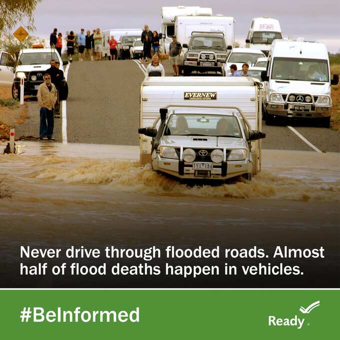
Among known hurricane-related fatalities, most are related to traveling during or following the storm; the Louisiana Department of Health confirmed that a man drowned after attempting to bring his vehicle through floodwaters in New Orleans. Additionally, Mississippi Highway Patrol reported a road collapse early Tuesday morning on Highway 26 that resulted in two fatalities and 10 injuries. The highway is closed until further notice and local officials are urging residents to generally remain off roads to avoid potential injury.

Federal Emergency Management Agency (FEMA):Ready Flooded Roads
As Ida continues to move across many US regions, states and communities should begin preparing for tropical storm-like weather and potential tornadoes. Additionally, FEMA encourages individuals to take the necessary precautions and prepare for flash flooding. Flash floods can develop with little to no warning, quickly changing the surrounding area. FEMA suggests individuals seek higher ground, avoid walking or driving in flood waters, and heed the warnings of local authorities. The Hagerty Blog Team will continue providing information and updates.
RELATED STORIES
STAY UPDATED AND LEARN MORE HERE:
- Remember, Ready.gov provides information on how to prepare for a storm and how to keep you and your family safe.
- Understanding the meaning of hurricane maps – a NY Times Opinion Piece: Those Hurricane Maps Don’t Mean What You Think They Mean

Keep track of Hagerty’s incident coverage here: