THURSDAY, OCTOBER 1, 2020 AS OF 1:00 PM EDT
2020 has been an unprecedented year and this year’s wildfires have been no exception. Wildfires have been plaguing the United States (US) West Coast for many months, marking some of the most severe fires in 70 years. In total, wildfires this year have burned over 5 million acres of US land. California experienced the greatest impact with over 3 million burned acres and 30 fire-related deaths. In total, at least 40 people have died from wildfires and over 7,000 structures have been destroyed.
In California, the largest active wildfire is the August Complex fire which started on August 16. So far, it has burned 938,044 acres and is 43 percent contained. Fires across the state continue to force evacuations, most recently a Marine Corps base, Camp Pendleton, had to be evacuated due to a brush fire that started on base. Additionally, across the State of California, the power company Pacific Gas & Electric (PG&E) have left over 87,000 people without power. According to the Los Angeles Times, the company “preemptively de-energized some of its equipment to avoid sparking wildfires and shut off power at other locations because of blazes already burning”.
Unsplash: Nikolay Maslov
On October 1 the National Interagency Fire Coordination Center reported the ignition of 53 new wildfires nationwide, and 42 uncontained large, complex fires. The majority of these new fires have started in Northern California, with several in the Pacific Northwest (WA, OR), Rocky Mountain (CO, WY, SD), and Great Basin Area (ID, UT, NV). As a result, large regions from Oregon to Mexico are experiencing moderate to unhealthy air quality. According to the California Independent System Operator (CIASO), the smoke has also decreased solar power generation.
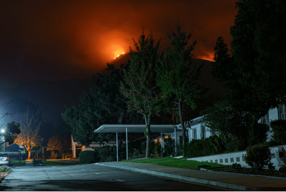
Update at 11 PM – The #GlassFire ? remains extremely active in the hills. Current weather along the fireline remains in the 80s with humidity in the 20% range. Winds are generally West to Northwest. #cawx #cafire Timelapse from Mt St Helena pic.twitter.com/a70dT8OtjH
— NWS Bay Area (@NWSBayArea) October 1, 2020
Glass Fire Timelapse from Mount St. Helena: NWS Bay Area Twitter

California Air Resources Board (CARB): Twitter
Additionally, the threat of new or worsened wildfires remains as a heat wave and abnormally dry winds blow into California this week, and communities are being told to remain vigilant as wildfires can ignite unexpectedly and burn quickly. It is important to follow state and local warnings, and those in fire-prone areas should consider signing up for community alerts. The Federal Emergency Management Agency (FEMA) recommends building an emergency supply kit or “GoKit” using this ready.gov suggested Emergency Supply List ahead of a potential fire. Additionally, with regard to COVID-19, consider including hand sanitizer and face masks in your GoKit.
PUBLIC ADVISORIES
To get a breakdown by State and County of public advisories, NOAA’s NWS has provided a list in decreasing order of severity:
RED FLAG WARNING:
- Lake County
- Southern Mendocino County
- North Bay Mountains
- East Bay Hills and the Diablo Range-Santa Cruz Mountains
HEAT ADVISORY:
- Carquinez Strait and Delta Region
- San Francisco North Bay – Interior Valleys to North Bay Mountains
- San Francisco Bay Shoreline – East Bay Interior Valleys
- East Bay Hills and the Diablo Range-Santa Cruz Mountains
- Santa Clara Valley, including San Jose
- Southern Salinas Valley/Arroyo Seco and Lake San Antonio
- Santa Lucia Mountains and Los Padres National Forest
- Mountains Of San Benito County and Interior Monterey County, including Pinnacles National Park
- Northern Salinas Valley, Hollister Valley, and Carmel Valley, including the cities of San Francisco, Santa Rosa, South Santa Rosa, Napa, San Rafael, Petaluma, Novato, Rohnert Park, Angwin, Lagunitas-Forest Knolls, Woodacre, Oakland, Fremont, Hayward, Daly City, Berkeley, Concord, Antioch, Livermore, Walnut Creek, Pleasanton, Pittsburg, San Ramon, Blackhawk, Scotts Valley, Boulder Creek, Day Valley, San Jose, Greenfield, King City, and Salinas
SMALL CRAFT ADVISORY:
- Coastal Waters from Point Arena to Point Reyes
AIR QUALITY ALERT:
- Lake County
- Northern Humboldt Interior
- San Joaquin Valley
- Eastern Curry County
- Josephine County
- Jackson County
- South Central Oregon Cascades
- Jefferson County
- Wasco County
- Siskiyou Mountains and Southern Oregon Cascades
- Klamath Basin
- Northern and Eastern Klamath County and Western Lake County
- Central and Eastern Lake County
HAZARDOUS WEATHER OUTLOOK:
- Southern Lake County
- Northern Lake County
RELATED STORIES
- Remember, Ready.gov provides information on how to prepare for Wildfire and how to keep you and your family safe.
- The Los Angeles Times regularly updated tracking of California Wildfires: California Wildfires Map.
- The National Fire Protection Association provides wildfire preparedness tips: link.
- Marin County provides a wildfire evacuation checklist: link
- FEMA provides an information video about how to be prepared for Wildfires: link.