TUESDAY, OCTOBER 18, 2022 AS OF 3:00 PM EST
According to the National Interagency Fire Center (NIFC), there are currently 71 large fires that have burned 651,947 acres across the United States (US), most of which are concentrated in the Pacific Northwest states of Idaho, Montana, and Washington. Fifteen active fires are burning a combined total of 48,000 acres up and down the State of Washington alone, including the Nakia Creek Fire, located in the Larch Block of the Yacolt Burn State Forest, nine miles northeast of Camas, Washington, a city that lies on the Columbia River, bordering the State of Oregon. Officials discovered the Nakia Creek Fire on Sunday, October 9; as of Tuesday, October 18, it has burned 1,565 acres with 5 percent containment. In a statement released on Monday, October 17, the Clark County Fire Marshal’s Office requested the public’s assistance in identifying persons and a vehicle of interest as they continued their investigation of the fire’s cause. In the Tuesday, October 18 update from the Clark Regional Emergency Services Agency (CRESA), which provides emergency management services for Clark County, Washington, officials reported that steady progress was made battling the Nakia Creek Fire overnight due to the cooler temperatures and high relative humidity, even though fog limited responders’ visibility. In an update posted on Monday, October 17, CRESA officials warned that while conditions look favorable, the public should stay prepared and exhibit caution as the conditions can change at any time.
We are at the morning briefing. Yes there is a lot of smoke. Its coming from multiple fires in region. Current Evac Notices have not changed.
Please be patient. an update will be out hopefully within the next couple hours. #NakiaCreekFire #Clarkwa #Vanwa #Wildfiresmoke pic.twitter.com/Cyfx7iqRNQ
— CRESA Talk (@CRESATalk) October 18, 2022
Twitter: CRESA Talk
EVACUATIONS
According to CRESA, the Nakia Creek Fire evacuation notices from the evening of Sunday, October 16, were still in effect as of Monday morning, October 17; however, in a Facebook post on the afternoon of Monday, October 17, CRESA noted that the evacuation zones are shrinking and some roads that were previously closed had been reopened.
Generally speaking, there are three evacuation levels for wildfires: Level 1 – Get Ready, Level 2 – Get Set, and Level 3 – Go Now. According to the Washington Department of Natural Resources, a portion of Clark County is currently at Level 3 – Go Now. More than 2,900 homes were ordered to evacuate from the Nakia Creek Fire, with another 33,000 homes facing evacuation warnings. The Larch Corrections Center, located only about five miles from where the Nakia Creek fire is burning, was evacuated Sunday, October 16, and the incarcerated individuals are being temporarily housed in other corrections facilities. The Washougal School District canceled classes for all its schools on Monday, October 17. Two schools, Cape Horn-Skye Elementary and Canyon Creek Middle School, were both located in the Level 3 evacuation zone. At the request of CRESA, the American Red Cross Cascades announced on Sunday, October 16, that it had opened an evacuation shelter in Camas, Washington, to assist those forced to evacuate. Additional shelters have been set up in two other locations in Clark County, as well as a livestock shelter location. CRESA urged residents on their website to “Please be patient, but be prepared.”.
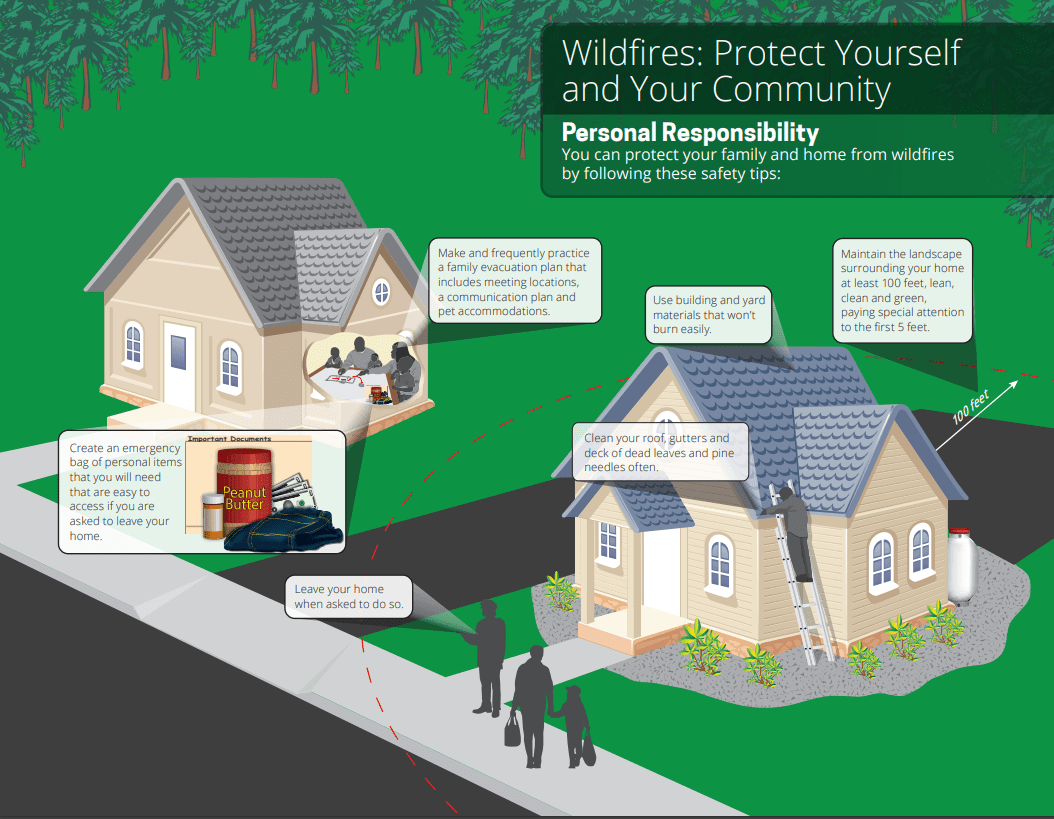
Protect Yourself and Your Community: US Fire Administration
The Federal Emergency Management Agency (FEMA) urges individuals to plan ahead for wildfire events, which can strike a community on short notice and spread quickly. FEMA encourages individuals to stay on top of the latest alerts in their area, including monitoring of the National Oceanic and Atmospheric (NOAA) National Weather Services (NWS) Red Flag Warnings, which indicate when critical fire weather conditions are occurring or will occur shortly. Individuals can also take advantage of real-time alerts available via the FEMA Mobile App and other local and national communication systems. It is also critical that households dedicate time together well in advance of a wildfire to create a wildfire action plan, including emergency meeting locations and evacuation routes, a communication plan, and an emergency supply kit, according to the California Department of Forestry and Fire Prevention (CAL FIRE). FEMA implores individuals to heed the warnings of local authorities and immediately adhere to evacuation orders in order to stay safe during a wildfire.
RELATED STORIES
- Remember, Ready.gov provides information on how to prepare for wildfires and how to keep you and your family safe.
- FEMA America’s PrepareAthon: How to Prepare for a Wildfire
- The Los Angeles Times regularly updated tracking of California Wildfires: California Wildfires Map
- The National Fire Protection Association provides wildfire preparedness tips:
- FEMA provides an educational video about how to be prepared for wildfires